Saturday 15 October 2011

What is weather 'news'?

We all know that exciting news stories sell copy and so one can't really begrudge journalists trying to put as much spin as possible on what they're writing. However, as meteorology is my passion and profession, such 'spin' is most certainly not welcomed by me.

I wish someone could explain to me exactly why the chance of snow in winter is worthy of histrionic front page headlines. Certain papers have been full of this for the last few weeks, giving the impression to the public that they should start running around like headless (or at least, scarf-less) chickens because it might turn cold again this winter. Snow in winter - whatever next?

What is of much more concern to me as a meteorologist is the fact that much of this 'news' stems from interviews and press releases from people who are not meteorologists (as far as I can tell, and I would be happy to be proved wrong - if I am, it's even more depressing).

If one was writing a news story containing information about some kind of new, deadly pathogen, surely it would be right to go along to someone who is qualified to pass comment about such a story, viz. a medical professional.

Why, then, does it seem to difficult to find a meteorological professional willing to pass comment in such outrageous news stories about the weather? I'll tell you why: because such professionals will give a balanced view of what they expect to happen, without hyperbole and ridiculous claims. This does not make a good news story of course, but the path to writing it would make good journalism.

What make me most angry about this is that when whatever is 'supposed' to happen doesn't, the public tar all forecasters with the same brush: "They (whoever, 'they' are) said we were supposed to get xxxxxx - I don't know why they just don't look out of the window/check the seaweed/insert other forecaster-belittling jibe here".

What can be done about this? It's hard to say. Many journalists are not sloppy, and so should take it upon themselves to source their weather information from reliable sources, i.e. well established meteorological companies, individuals, and organisations.

The simplest thing a member of the public can do, though, is to not take very much notice of over-the-top headlines. Source your weather information from reliable sources - you can probably work out who.

Thursday 2 June 2011

Back home!

We arrived back home yesterday morning and had a nap until mid-late afternoon. Had a good night's sleep last night and feel almost back on UK time now!

We had a great trip this year with several very impressive storms. As always, the US hospitality was spot-on, and having to wait a year before doing it again seems a very long way off at the moment!

Tuesday 31 May 2011

Lawton for last night

Well, nothing developed during the day along the dry line, despite strong instability - the capping inversion was too strong. This evening, though, a few storms have developed, perhaps as the low-level jet increased. However, we've moved eastwards to Lawton, Oklahoma, for our last night in the USA this trip. Perhaps we should have stayed in Childress, as that place is about to get a severe thunderstorm - oh well, perhaps the line will keep in tact until it reaches Lawton.

This year has been one of mixed emotions: we saw some fantastic storms, including the massive Canton tornado - it has dawned on me that it was my first Oklahoma tornado - all these years, and we've hardly ever chased in OK - this year, several chases were in OK; we enjoyed the hospitality of the USA - always a pleasure; however, we've also been appalled at the devastation which has been wrought by several of the tornadoes over the last 2 weeks (and of course, the spring as a whole) - thoughts go out to all the people and communities affected by these.

All that remains is for us to head to DFW for our flight tomorrow evening.

Monday 30 May 2011

Last day's chasing prospects

Our chase trip is almost done. One more full day before we head home. We can't make the trip way north into the moderate risk area around Nebraska, so we'll try our luck with the risk of an isolated supercell on the dry line close to western Oklahoma. We're currently in Elk City but will head west to Erick for lunch.

A few high based showers/storms

The cap was very strong today but a few showers and storms developed on the dry line in the NE Texas Panhandle, into Oklahoma and Kansas. We got on one near Shattuck and saw a bit of lightning and heard some thunder. Also saw a very small high-based funnel cloud but nothing more than than. Of greater interest, perhaps, was the heat. 38-39C at times through the day!

We're now in Elk City, Oklahoma. A chance once again for isolated severe storms down here - a better chance much further north, but we need to be in Dallas on Tuesday, so we're not going to haul miles and miles!

Sunday 29 May 2011

Lunch in Shamrock

Just stopped for lunch in Shamrock, TX, Car thermo says 105F - obs nearby suggest 100F - hot either way!

Cumulus bubbling to west on dry line.

May 29th - thoughts


Just 2 chase days left now before we head home. We need to be in Dallas on Tuesday afternoon so chasing has to be around the N Texas/Oklahoma area. It looks like at least isolated storms will be possible this afternoon and tomorrow afternoon in roughly the same area, along a dry line.

This morning, a small dry line surge has moved NE through Amarillo, but moisture lurks to the SSE and will likely move back close to Amarillo this morning before the dry line starts mixing eastwards this afternoon. With a strong southerly wind in the lower atmosphere, it is not likely to mix too far eastwards, and should lie through the eastern Texas Panhandle by mid-late afternoon. Ahead of this, reasonable moisture exists, but with such high temperatures expected today (38-40C) cloud bases look likely to be around 2.5-3km above ground. Shear through the cloud layer looks sufficient for high-based supercells with large hail the main threat. The fairly dry sub-cloud layer means that strong downburst winds may occur too. Early this evening, just a hint that around any storms which develop the LCL may become lower, but still not low enough - probably - for any tornado development.

This map shows the current dry line position, and an area which should see at least isolated storms this afternoon/evening. I think the Mangum to Hollis area looks good, but we may remain around I-40 for a time, near Erick or Sayre, to leave options open for heading a bit further north if needs be.

Saturday 28 May 2011

Is this the way...?

I think we'll blow-off the chance in Colorado today - this will more than likely ensure something good develops there. However, it's too far to do, especially when we probably need to be back in the Panhandle tomorrow, and certainly close to Dallas by Monday evening.

Thus, we'll probably go to Amarillo, so we can at least make it to the Big Texan!

Bustola!

Well, we busted today. The capping inversion was too strong, and despite some cumulus developing to our north, nothing happened. We've driven to Woodward, Oklahoma, for the night.

Tomorrow it looks like we'll head into Colorado.

Friday 27 May 2011

El Reno for lunch

Just stopped in El Reno for lunch. We're on the south side of town, which has luckily escaped the damaging tornado. The same, sadly, cannot be said for the northern parts, which got severely damaged on the 24th.

27th May outlook


A somewhat quieter convective regime over the next few days, with less of a focus to chase targets. The challenge of trying to pick a target is thus greater than a few days ago, but also very interesting.

Today, a surface low, currently around SW KS/OK Panhandle should move SE towards western Oklahoma. Meanwhile, a warm front will lift northwards and a dry-line will mix eastwards. Storms may develop along the warm front across NE Oklahoma. A more conditional risk exists close to the dry-line, west of Oklahoma City through mid-late afternoon. Instability will be high but the cap will also be strong. Lift around the dry-line and warm front from low-level convergence may be enough to break the cap, allowing isolated supercells to develop. Prime threat today is large hail. I think we'll probably target west or south-west of OKC to start but will probably hang around the metro area until obs show a more definite area.

Thereafter, tomorrow may see an upslope regime bring a few storms to eastern Colorado. It's obviously quite a haul up that way so we may end up heading in that general direction at the end of today.

A couple of storm videos

Here's some footage from May 21, around Topeka, Kansas. Hail and rapidly rotating wall cloud.

Watch in HD


Here's some footage of the wall cloud just prior to the Canton Lake tornado on May 24 - timelapse.

Watch in HD

Thursday 26 May 2011

Oklahoma City

Just arrived at the Cambria Suites, in Oklahoma City. Very nice motel! 2 flat screen TVs in our room; proper mugs for coffee; a Ferrari Testarossa downstairs!!

Canton tornado pictures

Here are some pictures of the Canton tornado


Wednesday 25 May 2011

Canton radar


Radar 3D volume of the Canton supercell. In time I will attempt to make a better colour table to pick out more features, but you can see the updraught above the tornado as the tilted column.

Canton tornado raw footage

Some HD footage of the Canton tornado:

Oklahoma high risk

We started the day in Blackwell, Oklahoma. With a very large risk area today it was tricky to pin down a target. There were some hints that the area around/west of Enid/Hennessey might be a good starting point. It was certainly a central place to start. Thus, we headed for Hennessey, stopping for lunch in Enid on the way.

By the time we got to Hennessey a storm had developed about 80 miles to the SSW. Storm motion was NE, so we decided to head west towards Canton to attempt an intercept. As we approached the storm the rotation was increasing on radar, and a tornado warning was issued. We got sight of the wall cloud which was rapidly rotating to our west. We inched closer until we reached a road junction. We stopped there and watched as a funnel developed, and then descended down, and a tornado formed. Quickly this grew into a large tornado, probably around 1/2 mile wide. We had no internet connection at this time but the Spotter Network client was running and so displayed the NWS Norman number. I put in a call to say that we were watching a large tornado 2 miles north of Canton, moving north. After a while this tornado vanished behind rain curtains, but we saw a further 2 fairly brief tornadoes.

At this point a huge convoy of chasers turned up. We decided to head south and then east to another storm, although this died out. However, we continued east almost to I-35 and then south towards Guthrie. A large, violent tornado, which sadly claimed lives to the west of Oklahoma City, was heading towards Guthrie. We couldn't see anything through the rain but we could see via radar that the circulation would pass very close to Guthrie. During this drive, various 'bits' were falling out of the sky in the rain, such as pieces of felt, and leaves. This was very eerie and pretty sobering/scary.

We stopped north of Guthrie to allow the circulation to pass to our south - the rain was intense and so there was no way we were going to thread the needle. CG lightning bolts slammed down all around and the sky to the south was almost completely dark - it was pretty scary stuff.

We then headed south and found branches blocking the road in north Guthrie. I got out to try to move them but one of them was pretty big. A chap turned up the other way in a large pick up. He simply got out, wrapped a chain around the larger branch, tied it to the truck, and pulled the branch out of the way. He then tossed the smaller branch out of the way. We could then pass through - many thanks whoever you were!

We then headed east and then south, to the south of I-44. Another supercell approached whilst we were in Chandler. Further bits of material were spiralling out of the sky amongst the rain. We didn't see a tornado from this, but it had produced several beforehand.

We then continued east, sampling the back of another supercell south-east of Bristow. We found some golfball sized hail and very strong north-westerly winds in the backside of the low-level mesocyclone, but couldn't punch east. We then pulled over to let the storm go. A short time later, the mesocyclone crossed the small town of Haskell. When we drove into town a little later we found police everywhere with the main road closed. A tornado had passed through although the damage didn't look really bad, but it was damage nonetheless.

We then headed to Tulsa for the night and had dinner and Applebee's.

Pictures and video should be uploaded shortly.

This was a very nasty day of severe weather and our thoughts go out to all those affected by the storms today, and indeed the last several days.

That's probably it for today

We decided to try one more cell, near Beggs. Got some very strong winds and golf ball sized hail, but couldn't punch through the very wet RFD to the front. Many of the storms today have brought masses of rain, thanks to the very moist atmosphere.

I think that is us done now - time to head to Tulsa.

Bristow

Just stopped in Bristow, OK, to take stock. I think that's our chasing done for the day. Full report later, but a 1/2 mile wide tornado near Canton (which we called in), large hail, a tornado passing to our south in Guthrie, which we did not see, but were close to, and then more hail thereafter. Phew.

Tuesday 24 May 2011

Tornado


Pic from back of camera


Tornado

Tornado near Canton

Just saw a large tornado north of Canton, Oklahoma. Debris was seen too - I'm very concerned it may have gone close to a camp-ground - a number of first responders have been seen racing towards the town.

Tornado near Canton

Just saw a large tornado north of Canton, Oklahoma. Debris was seen too - I'm very concerned it may have gone close to a camp-ground - a number of first responders have been seen racing towards the town.

Major tornado outbreak likely today in central/southern Plains

Not sure whether anyone in the USA reads this blog - if you do, and you're in the central or southern Plains, please be on high alert for severe weather today.

A strong upper trough will move in from the south-west today. Ahead of this, a strong southerly wind will transport rich Gulf moisture into the Plains. A dry-line will move slowly eastwards into western Oklahoma, NW Texas, and SW Kansas. Thunderstorms will likely form along this dry-line this afternoon and then move NE into the richer Gulf air.

A deepening low over Kansas will cause winds ahead of the dry-line to back into the SE, and wind fields at all levels will increase quickly this afternoon. High to extreme instability looks to develop in the moist sector. These ingredients point towards the development of intense supercells by 4pm CDT. The strength of the flow and the instability, including high low-level instability, will likely allow for the development of strong, possibly violent tornadoes, which may be long-track.

Needless to say this is a potentially very dangerous situation. Chasers will be out in full force today, I've no doubt about that. We'll likely opt for hanging back a bit from storms, as chasing only 2 weeks per year means that we don't get much practise in such volatile situations.


Back in Blackwell

We decided to stick with our target area today, rather than head south to the larger cluster of storms in central Oklahoma. There were tornado reports from this area of storms to our south, but these occurred whilst we were quite a way to the north, so there was little point in racing after these storms.

We managed to see a very thin, high-based funnel cloud out the back of one of the storms we intercepted. We also noticed a hail core on radar to our north, and so took a trip into it and found some 1.25-1.75 inch stones.

These storms then died out and so we headed back to the motel. Just under 80 miles for the day and done before 7pm!

The storms to our south are still going, and a number are still severe warned. On another day we might have dashed south into these but this trip is more about chasing our target each day. OK, so we might miss out but the ultimate verification of one's target area is driving there and sticking it out!

Tomorrow will probably be the last chase day until later in the week, as a major upper trough moves through and a cold front pushes the moisture south and east of the Plains. Indications are still that a potent severe weather set-up will develop tomorrow afternoon and evening across the central and southern Plains. We might allow ourselves to be swayed rather more tomorrow by developments rather than sticking solidly to our initial target area!

Almost forgot to add: the anvil from the storms to our south has and is producing some very nice mammatus clouds across us at the moment.

Monday 23 May 2011

Just west of Medford

We've stopped just west of Medford to await further developments. A few cells seem to be going up on the dry-line to the west. Radar suggests a small circulation around this area along the old outflow boundary. I think we'll see whether anything can interact with this feature.

Waiting in Blackwell

Just had lunch in Blackwell, OK. May head west in a little while but the old outflow boundary is in this area so we may not have to go too far.

Helen has just found a 1944 1 cent coin (penny) in her change.

Waiting in Blackwell

Just had lunch in Blackwell, OK. May head west in a little while but the old outflow boundary is in this area so we may not have to go too far.

Helen has just found a 1944 1 cent coin (penny) in her change.

May 23rd thoughts


A frontal boundary is orientated NE-SW through the Plains, with a dry-line extending south-westwards from a surface low across SW KS/OK Panhandle area. Very moist air is to the south and east of these features. Overnight storms in NE Oklahoma have left an outflow boundary in the area. Diurnal heating will lead to a very unstable airmass by afternoon, and a number of thunderstorms are expected to develop. Shear is expected to be sufficient for supercells as a shortwave moves through the area this afternoon.

Low-level flow is not especially high, and surface winds are slightly veered at the moment. However, the approaching upper system may allow for some pressure falls to the west, backing the flow slightly.

The target today would appear to be quite large - I think N or NW Oklahoma, as the surface flow could remain backed a bit more with the outflow boundary in place. We're still in Blackwell at the moment, and may well book another night here as tomorrow's outlook suggests this area and perhaps areas east. Indeed, a glance through the various forecast ingredients tomorrow paint a potentially dangerous situation.

Almost at hotel

Just turned southbound on I-35 towards Blackwell. The sun has just set and the eastern sky is darkening quickly. We can just make out distant thunderstorm towers, and the one to our SE can be seen flickering away - it's a mere 120 miles away!

Severe thunderstorm for us - but a bad situation in Joplin

We intercepted several severe warned/tornado warned thunderstorms to the east of Independence, Kansas today. Saw some large hail (hen egg size) along with strong winds, and several lowerings. There was also a lot of close CG lightning. Thus, for us, it was a fun chase with little overall impact to the wider populous.

However, recently a powerful tornado has ripped through parts of Joplin, Missouri. We didn't pursue the area of storms eastwards and so didn't see this. Judging by the initial reports coming out I'm quite glad we didn't see it, as it sounds very bad indeed. I've no doubt this will make the news back in the UK, as the reports I've seen thus far lead me to believe that the damage has been extensive. Thoughts go to all those affected by this storm.

We've decided to head west towards our motel for the night, which is in Blackwell, Oklahoma. Tomorrow and Tuesday bring a risk of severe thunderstorms and tornadoes to portions of the southern Plains, especially Oklahoma. Tuesday looks a very potent day indeed.

Sunday 22 May 2011

Choices, choices

A pretty huge area of severe thunderstorm risk exists today, so picking a target is not that easy. In part, though, it could be determined somewhat by where we would like to end up this evening ready for the next couple of days - these show a strong risk for supercells and possible tornadoes across Oklahoma. Thus, rather than heading east from Lansing into the middle Mississippi river valley and surrounding parts, where the highest risk of tornadoes appears to be today, we'll opt instead to head south. The cold front/dry-line will edge eastwards today, and widespread moderate to high instability will develop ahead of these features.

Indications are that a subtle upper trough will move in this afternoon from the west, with a speed max noted moving eastwards across southern Kansas. This should induce slight surface pressure falls ahead of it across SE Kansas. It may also allow a slight dry-line bulge to develop across NE Oklahoma/SE Kansas. Just ahead of these two features the low-level flow could back just a shade. With this in mind, I think we'll be heading towards Independence, Kansas.

Amazing chase day!

The day started overcast in Salina, Kansas, but the sunshine soon developed. We left our hotel around 11am and headed north to I-70 before heading east. We stopped for lunch at a Subway at Maple Hill. We spent a couple of hours there awaiting convective developments as the atmosphere continued to warm. Convection started to bubble to our west by late afternoon and we headed just south of town to see a developing couple of cells to our south. We watched these for 15-20 mins or so before heading back to the Interstate. We didn't want to be on the north side should these cells become supercells.

We continued eastwards until we reached the junction with highway 4, just west of Topeka. We dropped southwards and then parked up to observe two updraughts: one to our WSW and one to our NW. The southern one looked more interesting, and it wasn't long before marble sized hail began to fall. Then it got towards ping-pong size and we decided to drop south out of the core. Twin wall clouds were to our west, and so we stopped again.

The southern wall cloud looked more interesting and we managed (not especially wisely) to let it pass right over us, with funnels forming at times. The RFD started to kick in more and as the wall cloud moved east of us, the rotation became more concentrated.

Further funnels developed at times as we criss-crossed through Topeka to the north before heading east again. We saw some minor tree damage in southern Topeka, probably from the RFD.

We continued east on highway 24 towards Perry with a new wall cloud taking shape to our east. At least one of the funnels was reported as a tornado during this time - before we fully claim our tornado we'll have to check other reports, etc, to see at which point it touched down, as we weren't close enough to see touchdown.

We ended up heading north towards Oskaloosa. We watched the storm move east, now outflow dominant, with other storms producing frequent lightning to our north.

We booked a room in Lansing - I think it was the last one left at this hotel! We ate dinner at Applebee's - other chasers were there too - I think it was the Twistex crew.

Got back to the hotel and picked up the phone to ask reception what the Wifi code is. Decided to check welcome pack one more time first so put phone back down. A few seconds later the receptionist rang to say had I dialled 911 - I said no. However, the police had to come along anyway! I explained to the officer that I'd not touched any numbers - he was fine with it. Now I'm not going near that phone again!

It was a great chase day - we placed ourselves pretty much exactly where we needed to be.

Video will have to wait until we check into a motel with a faster internet speed to upload!

New base to west

First storm has passed - new storm to our west with rain free base.

Stunning structure

funnels

Just seen a series of funnels and a wall cloud at Topeka. Incredible storm - the wall cloud passed right overhead!

Saturday 21 May 2011

Cells developing

At the same spot as before. Cells have developed to our south, and one has become severe warned. Had a look via a nearby county road. Now about to head eastwards.

Lunch time

Hello. We've just stopped for lunch at a Subway about 15 miles west of Topeka. Latest hi-res rapid cycle models suggest convection may fire west of here. Whilst I'm not sure I believe exactly where it has convection developing I think we'll hang around here before we get too far east. It gives us some reasonable road options too.

Eastern Kansas

Morning! I popped downstairs to get some coffee a little while ago. The first attempt saw me pour most of it on the floor. A helpful gentleman told me to be careful as it was hot. The coffee, not the floor. A second attempt saw me get the coffee to obey the law of containment and it made it back upstairs for me to consume it.

Anyway, after looking at the analysis and model guidance I think we'll initially head eastwards to Topeka. A surface front/dry-line will move slowly eastwards today as an upper short-wave trough rotates around a major upper low to our north. A surface low, currently in SW Kansas should lift north-eastwards. Models hint that this will tend to open out into more of a wave through the day, and there are some complications shown on models in regard to how it will evolve. However, the general consensus is that surface winds will remain somewhat backed just ahead of the low, and 850 mb winds should pick up along and to the south of its track. To that end, areas to the south of Topeka may well be best, but as storm motion should be to the ENE, Topeka should be a reasonable starting point.

Back in Salina


Just got back from dinner at Applebees in Salina. Nothing much more happened after my last post. We saw another storm with a reasonable gust front and a few CGs. Headed back east and stopped by a windfarm to do a bit of timelapse and photography. Saw the Weather Channel Great Tornado Hunt team drive past. Also met a lady who had come up to take some pictures - here's her website - http://www.liskproductions.com/


Got back to the motel and hit the pool and tub before heading out to dinner.


Tomorrow looks potentially like an east Kansas chase day - it's also the chaser picnic at Rocky's but I think chasing might have to take precedence.


Friday 20 May 2011

Waiting in Russell

Headed west of Russell after lunch and saw a few cells passing northwards to our west. A bit of lightning with these, and a few areas of mammatus. Headed back to Russell and I picked up a coffee at McD's. Just parked in the carpark there at the moment awaiting the cells which are moving from the south. Nothing too exciting at the moment but there are storms, and we're on holiday so it's all good.

Luncheon

Just stopped in Russell, Kansas, for lunch. Severe thunderstorm watch has been issued.

Friday's thoughts

Morning! Well, we've decided to extend our stay in Salina for another night. This is due to a couple of things: 1) today looks as good in this area compared to anywhere else, which is not great, but we don't fancy driving miles and miles when we might get something close-by!; 2) tomorrow looks reasonable just east of here - well, current indications are it does anyway!

Overnight, a line of storms (a QLCS) moved across us with some nice lightning and heavy rain. This has left us in a rather cool, moist, and stable environment just now, with plenty of cloud. To the west, a dry-line/Pacific front is located N-S through central Kansas, with some cloud breaks ahead of it. This is expected to move slowly eastwards this afternoon/evening. Some heating may allow scattered storms to develop along this feature. Upper flow is rather parallel to this boundary, meaning storms may interfere destructively with each other, as precip is vented northwards into other storms' updraughts. However, shear is sufficient for organised storms/supercell structures, if storms can form.

This risk extends along the dry-line/front, and so picking a target area is not easy. The best chance of a tornado will be where the surface flow is backed, and current observations show easterly flow along the I-70 corridor. This is likely to veer more to the south-east with time, especially if sunshine develops - indeed, it is already beginning to go more south-easterly. However, this somewhat backed flow, and lower LCLs with cooler air might give the best chances for tornadoes today. Somewhere west or even NW of Salina may be our target area but we have to be rather general today.

Salina for the night - chase summary

We've checked in to the Sleep Inn in Salina, Kansas. We've been out to dinner at Applebees and now back in the room.

Today was a fun chase day. We started in Blackwell, Oklahoma and headed to Pratt, Kansas for lunch. The target was always going to be the warm front close to the I-70 corridor in north central Kansas. However, I was concerned this morning about the depiction on several models of something of a dry slot moving in from the SW through the afternoon, which suggested that storms might form quite close to the warm front (as the convergence from the dry surge helped to initiate convection) and not have a great deal of time to get organised before crossing the warm front into cooler air. The warm sector was very narrow and so it was going to be touch and go as to whether supercells could form before reaching the warm front. One did organise and apparently produced a tornado just north of I-70, near Dorrance/Wilson. We entered the storm from the west and encountered very heavy rain and strong north-west winds. These shifted abruptly to the south as the rain stopped, and were very strong. This was possibly the developing circulation of the tornado crossing the road although we'll have to go back through the video to cross-reference the time the tornado was spotted and when we were passing to see if this encounter was prior to the report.

The rest of the afternoon and early evening was spent attempting to get ahead of the HP RFD to look back into the notch, but this is tricky with NNE'ward moving storms and only a handful of N-S roads!

We saw plenty of close CG lightning and some further pretty strong winds. No tornadoes today for us though.

We then headed east and south to Salina.

Tomorrow will be complicated by what happens tonight. Suggestions are anywhere from SW/Cent Oklahoma up into this area! Thus, up early in the morning for a quick swim and then it'll be analysis and model scrutiny!

In the storm

We're in the middle of a strong-severe thunderstorm in torrential rain! Tornado-warned but looks very outflow dominant.

Thursday 19 May 2011

Tornado warned cell

Just driven through the back side of a tornado warned cell near Bunker Hill, KS. Abrupt windshift from north to south, and a very strong southerly inflow ahead of the storm. About to head north to look into it.

Heading north again - moderate risk now

Now heading north again towards Great Bend. SPC have just upgraded to moderate risk, based on the coming together of ingredients. Towers have started developing to our north, with a thunderstorm near Hill City.

Saint John

Just stopped at Saint John. Don't want to head too much further north just yet as recent HRRR model runs suggest convection firing to our south in an hour or two's time. To that end we don't want to get out of position, although I still favour the warm front to our north at the moment.

Pratt for lunch

Just stopped in Pratt for some lunch. Now heading north towards Great Bend, as the warm front is up there. Will keep an eye back to the south, though, as recent HRRR model runs break out storms close to Pratt. Storm motion is to the NNE so anything which develops should come up towards us.

Central Kansas

Morning.

A broad brush approach to today would suggest central Kansas as a target but, of course, it's a pretty big area! To that end, much closer scrutiny is (as always!) required. Some models (e.g. RUC) push a small dry-line bulge in from the west through the day - it is hard to know whether something like this will actually happen, especially in the absence of major upper forcing. Even so, with a fast SW flow aloft, mixing west of the dry-line would suggest this flow reaching the surface over western Kansas and helping to bulge the dry-line eastwards. Other models, such as the ECMWF, don't really do this, although this is still the hint of a slight push eastwards. The one more general consensus seems to be that the best chance of breaking out precip is somewhere in the line from Hays/La Crosse kind of area, although anywhere down the dry-line could see an isolated supercell develop.

This evening, low-level flow will increase further as the low-level jet cranks up. Instability remains quite high, including low-level instability. A window may exist for a strong tornado this evening as this occurs, with storms tending to keep going into the night as the upper trough moves closer.

Blackwell

We're now holed up at the Comfort Inn in Blackwell, Oklahoma. Dinner was McD's tonight, as nothing else in town was open. We've got a seating area in our room, though, so we could at least sit down to eat!

Tomorrow still looks pretty interesting as an upper disturbance approaches from the west whilst a dry-line/warm front take shape at the surface. At the moment, somewhere south of Hays, KS - perhaps La Crosse, looks pretty good. However, will refine in the morning.

Looks like a bust

Despite pretty good moisture and instability, lift was not sufficient to break the cap today. This seemed to be down to an area of cirrus which overspread from the west during the afternoon. We spent several hours in Watonga, Oklahoma, chatting to other chasers, who were on Cloud 9 Tours (the Rees brothers, etc) and Charles Edwards, who runs the tours.

By early evening it became apparent that storms were not going to develop so we headed off. As the best chance tomorrow currently looks to be in Kansas we've decided to head to Blackwell, Oklahoma for the night. We're currently passing through Enid, Oklahoma.

Wednesday 18 May 2011

Towards Watonga

We've just turned northbound from I-40 onto US281 towards Watonga. Surface obs and short-term model guidance suggest the dryline bulge will continue to move into this area with the best surface convergence around here too. Cumulus are bubbling just to our west along the dryline. We're approaching Geary at the moment.

Lunch

Just at Clinton having had a bite to eat from Subway. Drivers now swapped so Helen is driving and I'm now at the computer. I think we'll continue eastwards into the deeper moisture then probably northwards towards the Watonga area. Backed flow looks quite nice to the north of Watonga and a slowly developing cumulus field is evident to our east.

Dry-line

Morning - just having some croissants in our room before heading off. Today will see a slow-moving area of low pressure across the TX Panhandle area, with a dry-line east and north of the low. Ahead of the dry-line, a moist (and moistening) airmass is being/we be drawn up ahead of the dry-line. Strong heating and the approach of an upper short-wave may be enough to allow convection to develop by late afternoon INVOF the dry-line. South-east of the low, the dry-line will likely bulge eastwards, with backed surface flow to the north-east of this. This will be the most likely location for tornadoes, should storms develop.

Models have generally not quite captured the location of the low and dry-line this morning although they've done a reasonable job - ECMWF seems to have the best handle. As always, models are only guidance and so observations will be closely monitored as we progress into Oklahoma.

Woodward to Enid seems a reasonable area today, but we'll initially head north to Shamrock, TX, to pick up I-40 east. We will then modify from there as observations, etc, dictate.

Return flow commencing...slowly

After a nice dinner at a (busy) Kettle restaurant here in Childress, we're back in our room. We're on the 3rd floor in an east-facing window. There is a dry-line bulge to our south at the moment, with a developing area of low pressure close-by. This has squeezed the pressure gradient across this area which is producing gusty south-easterly winds. Although the moisture is not that high at the moment, it is return flow nonetheless, and is whistling through our window fittings.

Now this might sound like an annoying prospect for sleeping, but for me it's a sign of increasing storm prospects as the Gulf moisture begins to return to the area. I'm sure I'll lie awake for a little while because of the noise, but thoughts of storms will be drifting through my mind like the wind drifts through the window.

It reminds me of an excellent piece of writing by Roger Edwards: http://www.stormeyes.org/tornado/return.htm

Childress

We've took a drive from Weatherford to Childress, Texas, via Wichita Falls, where we had lunch.

A few AcCas clouds en route, and a distant high-based shower formed to our south. At the moment, the dry-line is to our west, visible as distant high-based cumulus clouds. However, a fairly thick layer of cirrus spread from the west for a time this afternoon, which reduced surface heating - it really needed to be very sunny this afternoon to get anywhere near developing convection. The cirrus has gone now but it's likely too late for anything to fire.

To that end, we've gone ahead and booked into the (very nice) Holiday Inn Express in Childress. I think we'll hit the pool in a minute before getting dinner, probably at the Kettle, in which we've eaten many times before.

Tomorrow looks like a dry-line set-up in Oklahoma, with a somewhat better moist sector ahead of it. Storm chances are still low, though. Thursday looks more robust, as better moisture will be in place by then. The target for Thursday is somewhere east of the dry-line, but at the moment there are a number of factors which preclude homing in more clearly. Somewhere from central into northern Oklahoma or perhaps S Cent Kansas seems most likely at the moment. Some models hint at the development of a triple point over N Oklahoma, but this will require overnight and early morning convection to hold up the northwards progression of the warm front.

Tuesday 17 May 2011

Wal-Mart time!


Hello! After a good night's sleep, we're up and about. I headed to the pool and tub this morning but Helen had a bit more kip.

We're currently at the Wal-Mart in Weatherford, TX. Helen has gone to get some goodies. I think we'll probably wander up towards Childress today.

Car is shown below, as is a little patch of AcCas.


Here!

It's now 2250 local time and we've been up a long time! Bleary-eyed but glad to be hear it's time to get some well-earned sleep. Our car is a Dodge Journey SXT, or something, in black. Looks pretty good and has all manner of electrical outlets in the car, including a 115V US plug. This will be good for powering our stuff!

Will have a bit of a lie in tomorrow, perhaps a swim, and then see what's happening. Current thinking is that the dryline should drift towards the edge of the Caprock, so we may head north-west towards Childress and points just west of there to see if anything isolated can develop. Later this week still looks active, so we'll be gearing up for that.

Sunday 15 May 2011

Almost time

Tomorrow is departure day, as we head to Dallas, Texas. Storm chasing is the prime goal although we'll also take in some sight seeing, etc, across the fantastic Great Plains.

Storm chances look to increase through this week before, and the chances may continue into week 2, perhaps even more so.

Stay tuned!

Saturday 14 May 2011

Storm chances increase later this week

As departure time approaches for Helen and me, this blog will become more active.

It's looking like a trough will move towards the southern Plains later this week. Moisture will take some time to get back in but the dryline might be active with isolated storms from Tuesday onwards, but more likely Weds or Thurs. Thereafter there is a difference between ECMWF and GFS - the former is slower with the system departing; the latter a bit more progressive. The following week may see another trough moving in but somewhat further north - moisture *should* be more widespread by then but it depends on the first system - if it deepens more as it moves into the mid-south, a stronger offshore flow may develop and push moisture away.

Monday 25 April 2011

Tornadoes likely today in the southern USA

Several days of severe weather are likely across the USA, starting today. A deep upper trough will approach the central Plains states, with one short-wave trough moving through later today, before the main trough approaches tomorrow.

Strong southerly winds will develop ahead of these features, transporting Gulf moisture into the region, whilst a front will be draped in a general east-west fashion through the southern Plains and Mississippi river valley.

A dryline will mix eastwards this afternoon whilst a surface low develops and moves north-east. These will likely be foci for severe thunderstorms this afternoon, once morning convection across the area tends to shift away.

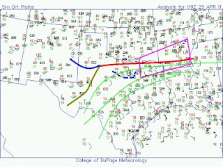
The image below is my analysis of the current situation - the purple box is where I think the best chance of tornadoes will be this afternoon/evening. NE Texas maybe a favoured location for mid-late afternoon supercells and tornadoes ahead of a dryline bulge. These storms will then likely propagate north-eastwards across Arkansas, but will likely grow upscale into one or more cluster(s) of storms, including supercells, as the upper trough moves in.

For a (virtual) chase target, I initially pick Clarksville, TX.


Wednesday 20 April 2011

Tornadoes in the US - results


A fair amount of severe weather occurred last evening and night across portions of the Central Plains and Midwest of the USA.

A number of tornadoes developed, including this one, caught by Reed Timmer et al:

http://www.youtube.com/watch?v=MwL1Hy4A1TE


As per my post yesterday evening, this and several other tornadoes developed ahead of the surface low, close to the warm front.

Tuesday 19 April 2011

Tornado warning in Missouri

Streaming TV coverage

Tornado warning in Missouri

Tornado warning now in Missouri - this is a confirmed tornado.

...A TORNADO WARNING REMAINS IN EFFECT FOR SOUTH CENTRAL PIKE COUNTY
IN WEST CENTRAL ILLINOIS...AND CENTRAL PIKE COUNTY IN NORTHEAST
MISSOURI UNTIL 445 PM CDT...

AT 401 PM CDT...NATIONAL WEATHER SERVICE DOPPLER RADAR WAS TRACKING A
CONFIRMED TORNADO ON THE GROUND HEADED TOWARD BOWLING GREEN. THIS
TORNADO WAS LOCATED NEAR CURRYVILLE...OR 5 MILES WEST OF BOWLING
GREEN...MOVING NORTHEAST AT 30 MPH.

LOCATIONS IMPACTED INCLUDE...
BOWLING GREEN...LOUISIANA...PIKE...ATLAS AND ST. CLEMENT.

Tornadoes soon in the Midwest


Another day, another outbreak of severe weather is expected in the USA. This time it's portions of the Central Plains and Midwest, especially Missouri and Illinois.

This chart shows the latest SPC mesoanalysis for sea level pressure and surface dewpoint. There is a well-marked warm front to the east of surface low, which is currently in central Missouri. Latest satellite imagery shows a deepening cumulus field around the low, the warm front, and down the trailing cold front to the south-west of the low.

Scattered thunderstorms should develop very shortly, especially INVOF the low and warm front. The low will move in the direction shown by the arrow, and low-level shear/helicity will be maximised just ahead of the low. The red polygon shows my interpretation of the highest risk of tornadoes in the next several hours, along the path and just ahead of the surface low.

Storms should develop down the cold front too, eventually turning into a line of severe storms, although initially some supercells are possible. Large hail, severe winds, and isolated tornadoes likely with these.

Thus, in short, another outbreak of severe thunderstorms will develop shortly, and the highest tornado risk, at least in the short term, in my opinion, is central Illinois.