Thursday 7 June 2018
Home!
Hello! Well, we're home now and already missing the wide-open Plains! It was a great couple of weeks.
Wednesday 6 June 2018
Packing up
Hello. We're packing our bags now and will head to Denver today ready for our evening flight home. It's been a great couple of weeks with many storms and catching up with friends.
June 5th - mountains!
Hello.
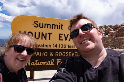
Today we drove from Denver to the top of Mount Evans, which is over 14,000ft above sea level. We managed to walk the last small part to the top, but at that altitude even a fairly modest bit of walking gets the heart pounding, and feelings of light-headedness. The sun is very strong at that altitude too.
After we'd reached the summit we headed down, and paused for lunch by a lake - still at 13,000ft above sea level.
We then decided to treat ourselves on the last night and booked into the Four Seasons at Vail, Colorado. I had a swim.
Tomorrow we will head to Denver and get the plane home, and arrive around the middle of the day on Thursday.


Tuesday 5 June 2018
June 4th - storms done with!
Hello.
We woke up this morning in Amarillo, checked various pieces of data and determined that storms were not likely nearby, and we weren't really interested in hanging around, so we decided to head to Denver and be tourist. Tomorrow we will go into the mountains.
The only pics today were from a (closed) rest area on US Highway 64 (the Sierra Grande rest area) near Des Moines, New Mexico, of a train.


Monday 4 June 2018
June 3rd report
Hello.
We targeted Albuquerque today. Storms were already firing off as we drove down from Raton, and we managed to get to a storm which had been tornado-warned, but it tended to wane, as new storms formed to its south.
We then headed east through very heavy rain, on I-40, and turned south at Moriarty. We saw some nice cloud structure on the way south as a supercell approached, although it became more linear after a while.
We then headed east to Vaughn, pausing to look back at the line of storms. At Vaughn we let the storms roll over, although they were non-severe by then where we were, but there were some good, close lightning bolts!
We then decided to head to Amarillo for the night as there is a risk of storms around this area on Monday.
All in all a reasonable chase day which behaved as expected.


Sunday 3 June 2018
3rd June - lunch
Hello.
We've just stopped to pick up a sandwich from Santa Fe, New Mexico, but will soon continue SW towards Albuquerque - a severe thunderstorm watch is in effect and a severe thunderstorm is already some way to our SW.
We've just stopped to pick up a sandwich from Santa Fe, New Mexico, but will soon continue SW towards Albuquerque - a severe thunderstorm watch is in effect and a severe thunderstorm is already some way to our SW.
Brief tornado video from May 28th
A short clip of the two brief mesocyclone-spawned tornadoes from May 28th, 2018 - taken with my GoPro4, near Cope, Colorado - this was after the numerous 'dusty' tornadoes (most non-mesocyclone).
https://youtu.be/9Tj8-u-i9rw
https://youtu.be/9Tj8-u-i9rw
June 2nd report
Hello.
Fairly straightforward day today - drove from Grand Island, NE, to Raton, NM - about 585 miles. As we approached Trinidad, CO, just after sunset, we noted smoke from the large fire around Ute, NM. There were various waves, etc, in the smoke.

Fairly straightforward day today - drove from Grand Island, NE, to Raton, NM - about 585 miles. As we approached Trinidad, CO, just after sunset, we noted smoke from the large fire around Ute, NM. There were various waves, etc, in the smoke.

Saturday 2 June 2018
June 1st report
Hello.
We started the day in North Platte, Nebraska. We decided to target the area around Broken Bow/Ansley. We headed to Broken Bow and had our lunch there. A cold front was approaching from the west, and storms formed along it from north to south as the afternoon progressed. We targeted a promising cell, but it became linear quite quickly. Storms formed increasingly quickly southwards along the cold front such that it was really just a line of storms by early evening. A brief tornado did occur north of where we were, as we moved south, and we didn't see it - but a few chasers did.
We got to Ansley, briefly pausing at the gas station where we stopped ahead of last August's eclipse, before heading SE on the road to Grand Island.
We stopped a couple of times to look back at the storms, as there was a persistent cell on the southern end for a time, which may have been a supercell.
Near Ravenna we stopped for a while and I took some lightning pics. We saw a wall cloud evolve to our NW, and soon a tornado warning was issued for this part of the line. We saw a couple of funnel clouds, and a couple of people reported seeing a brief tornado.
We then headed to Grand Island and had a late dinner in Perkins. It's now 0143 and we can hear occasional thunder, and train horns.


Friday 1 June 2018
June 1st - lunch
Hello. We started the day in North Platte. The south-easterly wind had picked up and the dew points were high, so it felt much more like a typical severe weather day from that perspective.
The general target area was to the ENE - so we have driven to Broken Bow, and will either hang around here, or head to Ansley, and await developments.
The general target area was to the ENE - so we have driven to Broken Bow, and will either hang around here, or head to Ansley, and await developments.
Thursday 31 May 2018
May 31st plans
Hello. A travel day today...we will head for North Platte, Nebraska. A risk for severe storms in the northern Plains tomorrow.
May 30th report
Hello.
Just a brief write-up as it's now 1.47am!
We left Enid to head pretty much due west to the Oklahoma Panhandle, stopping at Guymon for lunch. Thunderstorms had formed over the higher terrain of New Mexico (and Colorado) and were heading in a general east direction.
We headed west to Boise City, and noted a 'tail end' storm on the southern side. We dropped south-east and then south - the updraught bases of these storms were visible to the west, over 40 miles away! We paused for a time to watch - but there were a lot of flies around, mainly midge-type flies...not pleasant!
We then kept (just!) ahead of the storms as the moved ever more quickly eastwards, eventually stopping to watch the southern storm move away to the east from a point south of Perryton. We had observed some nice structure to the storm, lots of dusty outflow, and, now, as it moved away into the evening darkness, impressively-frequent lightning.
We decided to stay at Dodge City - but it was a 160 mile journey, much of it through rain, so we were pretty tired by the time we got here after midnight. Further frequent cloud-ground lightning for a time as we drove north, but it was dry in Dodge.
All-in-all a great chase day!


Wednesday 30 May 2018
May 30th thoughts
Hello. We're starting the day in Enid, Oklahoma. Storms should develop on the higher terrain of NE New Mexico and perhaps SE Colorado and then move ESE overnight. We'll head west towards Guymon, Oklahoma, and await developments.
May 29th report
Hello.
We started the day in Burlington, and set our sights on S Kansas/NW Oklahoma. We headed for Dodge City for lunch, and then continued south.
We got onto a big storm in NW Oklahoma and followed it all the way across to Enid, where we are staying the night. The storm had some good rotation at times, but we never saw any ground circulation - however, there was some impressive cloud motions. Early on, we saw a very strongly rotating lower portion of cloud, which was occluded from the main updraught. Later, we saw a strongly rotating wall cloud which very nearly produced a tornado, but not quite.
In the end the storm ran over us at Enid, but the large hail passed south of town - but it got very windy for a time. Another severe storm passed over as we finished dinner at Applebee's, and so we got rather wet getting back into the car. A few chunks of hail came down, but not much - plenty of close lightning and loud thunder!
A few chasers caught a very impressive tornado near Dodge City - something which is a little painful to see for us as we had passed through at lunchtime, noting the decent low-level shear, etc!


Tuesday 29 May 2018
May 28th report - tornadoes!
Hello.
Today was a cracking chase day. We started in Cheyenne, and decided we would target a very obvious outflow boundary across NE and E Colorado. We headed for Limon, but in the end carried on past Limon a few miles, to Bovina. We met up with a couple of chaser friends, Dan Holley and Pete Scott. We watched the sky for a while, noting the pronounced low-level shear as the bases of the cumuli moved south-westwards, whilst the tops were being pushed to the north.
After a while we decided to continue eastwards, reaching Flagler, where we picked up some lunch - but didn't eat it then - we needed to push on! A storm had developed to our north-west, so we made it to Seibert, and then headed north.
On our way up to Cope we noticed some dust off to the west, which turned out to be a non-mesocyclone tornado (colloquially known as a 'landspout' - they form from local vorticity being stretched by a passing updraught rather than by complex interactions underneath a strongly rotating low-level mesocyclone - they're still tornadoes, though!).
We then continued north to Cope and then westwards by a few miles. We found a good vantage point but the extensive low-level stratus clouds being pulled into multiple updraughts meant we couldn't see much structure.
However, what we did see was a series of further non-mesocylone tornadoes developing one after another, some way to our south-west. At times, at least 2 were occurring at the same time.
These appeared to develop on the flanking line feeding into the main updraught, which soon started to exhibit strong low-level rotation. Hail started to fall so we retreated eastwards by a few miles.
We could then see the low-level mesocyclone just to our south-west, which tightened up and produced a brief tornado, which quickly got wrapped in rain. We headed east again, and then looked right into the notch of the HP supercell, and another tornado developed just about a mile to our west. It was a narrow rope tornado, but was heading towards us. When it was within about 1/4 mile we decided to head off to the east.
The storms then formed more into a line, and so we headed, via several stops, to Burlington. We decided to stay here for the night, despite the prospect of a long drive tomorrow to SW Kansas, the TX Panhandle, or W Oklahoma. We saw a number of other chasers when we went for dinner at The Dish Room - which was a very good place for dinner!


Subscribe to:
Posts (Atom)