Tuesday 24 June 2014

Looking back 20 years - the severe thunderstorms of June 24th 1994 in S England

As a first year student at Reading Uni in 1994, this day in that year was one which sticks in my mind - less for the maths exam I dashed through (passing, thankfully!), and more for the intense thunderstorms which developed/moved north during the evening.


It was a reasonably classic deep southerly flow, perhaps a Spanish Plume: 

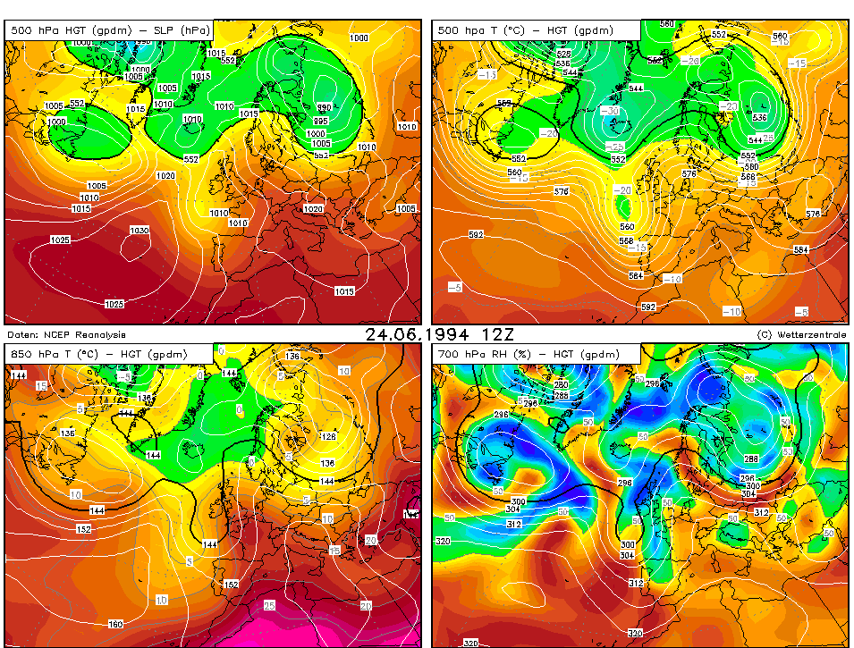
During the previous evening, AcCas blossomed across the Reading sky as the EML drifted north - the 12Z Herstmonceux sounding from the 24th shows a pronounced EML. Modifying this with the Camborne 12Z 900-700hPa temperature profile (making a very broad assumption that the approaching upper trough from the west caused cooling via lifting above a capped boundary layer, across eastern areas, leading to a similar 900-700hPa profile to Camborne's) and using the max temps (29C) and approx dewpoints in the warm sector yields sizeable and deep CAPE. As the trough approached upper flow increased too, with enough shear for well organised multicell thunderstorms, and perhaps updraught rotation.

From my point of view, after finishing the exam I went back to my hall - after dinner, at around 6.30pm, a large, thick cirrus shield overspread the sky from the south. About an hour or so later a thunderstorm commenced, bringing frequent lightning, strong winds, and plenty of rain. It went on for a couple hours before moving away - it was a very impressive storm although I think the storms further east were even more intense.

Here is some BBC forecast footage:


And some YouTube footage from a chap in Great Baddow, Essex:

Thursday 5 June 2014

Home!

Hello! We're back home after this year's trip...it was an enjoyable one, even though it was a rather quieter year than some recents ones. Even so, we saw some great storms and had a lovely time.

To top it off we got bumped to business class for the flight home, which was nice!

Wednesday 4 June 2014

June 3rd - final day long shot - no!

Hello.

We thought we'd try a long shot at getting some afternoon convection in S Cent Nebraska - we knew all hell would break loose further north as storms fired along a warm front, but it was too far for us to go, knowing we had to head back to Dallas on Wednesday. Also, the type of storms expected - large, violent high-precipitation supercells with limited tornado potential, and little chance of seeing a photogenic tornado made it less appealing. So we gambled and drove from Salina, Kansas, to Red Cloud, Nebraska, which is a lovely little place. We had lunch and mooched around the local area for a couple of hours - very nice, but no storms.

At 5.30pm or so, it was clear nothing was going to happen soon, if at all, so we bailed, and drove to Oklahoma City. We stopped for McD's on the way down - our first of the whole trip!

We're staying overnight in N Oklahoma City, ready to drive to Dallas in the morning.

It's been a nice trip, if fairly quiet storm-wise. We've seen some cool storms and some nice structure at times, but no tornadoes this year.

Tuesday 3 June 2014

June 2nd - S Kansas bust

Hello.

It was a long shot to get convection today in the Plains, as an upper ridge built in, decreasing lapse rates and stifling any towers which could develop.

We decided to head to southern Kansas, just in case an old outflow boundary could cause enough low-level lift to allow storms to form. A few showers did develop in the end, and we did drive through some brief heavy rain - however, there just wasn't the persistent lift to really get things going, and the convection always looked fairly anaemic.

We decided to head to Salina - tomorrow, a large area of Nebraska and parts of N Kansas appear to be in line for a severe weather outbreak, with the risk of supercells and strong tornadoes. We have to be in Dallas on Wednesday for our flight home, so this will modulate how far north we are prepared to go tomorrow. We'll have to await the morning models and see how any overnight convection affects the set-up. If it appears it'll be well into Nebraska, we may just call it quits and start heading south - however, if there's a chance in S Nebraska/N Cent Kansas, which there may well be, we'll hang about.


Monday 2 June 2014

June 1st pics

Here are a few pics from yesterday.


June 1st - messy storms in Kansas

Hello.

We had a later start than planned as I turned off the alarm clock when it first woke me at around 0840 and thought we'd have 5 more minutes. When I next looked it was just after 1000! The plentiful driving and late nights have started to take their toll and so we needed the sleep. We packed our stuff, but thunderstorms were already developing/ongoing, and a strong gust front moved overhead around the time we wanted to check out. Cue torrential rain and strong winds! I reversed the car right up to a door, into a kind of porch area - it clearly wasn't meant to be used like that but we didn't want to get soaked!

We headed south into Kansas, and stopped for lunch in Oberlin. Several other chasers were there too. After a while a storm developed to the west, but soon fizzled. We decided to head south to intercept storms to the south and south-east of Oakley. We did this, but the storms morphed into something of a mess - this was expected today, but it's a shame it wasn't a bit later! Even so, we saw some great lightning and some interesting cloudscapes. We could have continued south to try to get to the south end of the line - which would have yielded better storms - but we decided to just hang around and take in the sights and sounds of the prairie, with the storms rumbling away.

Whilst taking some of this in, a car pulled up and a lady called Lori chatted to me for a while about storms and living in Kansas - it was lovely to meet her - the folks out here are very friendly.

We then decided to head east - another thunderstorm developed overhead and we watched that for a while - it gave us a great rainbow too.

We ended up in Hays, and ate in Applebee's - where else?! It was packed - some kind of dance event was going on.

No pics tonight as it's late now!

Sunday 1 June 2014

May 31st - Wyoming storms/funnel cloud

Hello.

We had a leisurely morning in Cheyenne - Helen did a little shopping for a few albums, etc, and we had lunch in Subway. By around 1.30-2pm a few storms were forming to the west and north-west, and we drove out of town to the north-east, and parked up to watch. We spent a pleasant couple of hours just watching a cell to our NW go through various stages of development, before eventually dying out. A new cell to our NW looked more promising, but a line of fairly weak storms to the south was pushing an outflow boundary northwards. We decided to head further north to be in a better position to intercept - I remarked to Helen that we should keep an eye on the base of the developing supercell as the gust front moved in - sure enough, in the distance to our west we saw a suspicious lowering quickly develop and take on a funnel shape. We pulled up as a report came in from chaser Daniel Shaw that a funnel had been spotted. It was around 30 miles to our west, but we just happened to be in a spot where we could see it across the open landscape (which, I should add, is stunning!).

After it disappeared we continued north and then west - at this time the supercell was being overtaken by the gust front from the south and south-west, and the base took on a more linear appearance. It still looked very cool and we got some good pictures. We then decided to head to Torrington to let the storm's core passed over - it did, with winds gusting to around 50mph and pea sized hail. Nothing too bad but still very nice nonetheless, and with plenty of thunder and lightning.

We then headed SE through Scottsbluff to I-80N (we saw a nice storm to our west, backlit by the setting sun, as we did so), and then to North Platte, where we're staying - we have a balcony! We ate dinner at Applebee's with Nathan Edwards.

Tomorrow brings a risk of severe storms over quite a large areas, especially Kansas. Scattered supercells with large hail and damaging winds, and perhaps a tornado, will likely grow upscale into one or more MCSs (Mesoscale Convective Systems) through the evening, and may pose a windspread damaging wind threat.