Thursday, 6 June 2013
Home!
Hello. We've just got home from the USA. Happy to be home, sad to have left. The events of May 31st have left an indelible impression on us both, though.
Wednesday, 5 June 2013
Almost time to leave
Hello. We did most of our packing last night. Just a few bits to do this morning and then it's off to DFW for the flight home. It's been a full on trip this year with great memories and sad ones too. Certainly not one which will be forgotten.
Tuesday, 4 June 2013
June 3rd report
Short: Intercepted several storms in the Oklahoma and Texas Panhandles, culminating in a stunning supercell.
Long: We awoke in Amarillo, and I decided to dust off the Speedos and do a bit of morning swimming - annoying kids in the pool meant I only swam for a bit before my annoyance levels took me back to our room for coffee.
We left Amarillo around noon/midday/1200, whatever it's known as, and headed north towards Guymon, Oklahoma. We were targeting the Panhandle region, as moist upslope flow combined with weak lift from an upper system meant that scattered showers and thunderstorms should form, and then become severe as they moved east and south-east into somewhat moister air.

After lunching in Guymon, where it was 38C (!), we headed a bit north and east, to just east of Hooker, Oklahoma. We then spent a while watching convection try to form but having a tough time. My mood become a bit despondent with it all for a while but spirits were lifted as a storm to the north-west took on a more solid look (above shows me watching it starting to form). We headed north, and started to see CG lightning coming out. Here is a lucky shot I took (below).


Long: We awoke in Amarillo, and I decided to dust off the Speedos and do a bit of morning swimming - annoying kids in the pool meant I only swam for a bit before my annoyance levels took me back to our room for coffee.
We left Amarillo around noon/midday/1200, whatever it's known as, and headed north towards Guymon, Oklahoma. We were targeting the Panhandle region, as moist upslope flow combined with weak lift from an upper system meant that scattered showers and thunderstorms should form, and then become severe as they moved east and south-east into somewhat moister air.


A number of our UK storm chase friends were also on the storm, and turned up!

After a while we went our separate ways, and we headed east, to keep viewing the storm. However, it became clear that, whilst nice looking, it was going into a region where it would be tricky to keep following it by road, so we dropped south onto a new storm. We noticed on the Spotter Network that our friends Nathan, Pete, and Steve, had stopped, and the radar looked very interesting - we decided to drop down to see what had got their attention. It was a stunning supercell - we already had realised it was a supercell from the radar, but one look confirmed it. We pulled up next to them and spent quite a while in one place documenting it - this was south of Beaver, Oklahoma (below).
We then had to drop south, but stopped again to watch and document it some more (below). Soon it became apparent that we needed to get south and east before the angry RFD got us, so we headed down to Booker, where the sirens were sounding (the storm was warned for 80mph winds), and then east. After watching it some more we decided to leave it after dark, and we went our separate ways. Helen and I ended up in Elk City, and a brand new Sleep Inn. No places to eat though, so it was dirty microwave burgers and chips from Walmart! A far cry from the Big Texan last night! One more chase day tomorrow and then it's to Dallas on Wednesday for the flight home.

Monday, 3 June 2013
June 2nd - is this the way?
We decided we would head to Amarillo today as we didn't want to head miles south-westwards into New Mexico. It gave us the chance to do two things: visit the Palo Duro Canyon State Park, and eat dinner at the Big Texan Steak Ranch - these are both things that anyone visiting the Amarillo area should do.
Needless to say our minds were in a fair degree of turmoil following the tragic news I conveyed in a previous post - it was almost a continuous cycle for me, one of thinking it can't possibly be true, then realising it is, and then trying to accept it, and then again. And I didn't know them personally - I can't begin to imagine what those that do are going through.
The visit to the canyon gave us plenty of quiet time to enjoy the scenery and to take it in, and savour the moment. One must always savour such moments, indeed, all moments.
We spent a very pleasant several hours taking pictures, driving around, and getting out and enjoying the Texas sunshine - it seemed a million miles away from tornadoes and tragedy.
We then headed to Amarillo - trying not to have the infamous song going around in our heads - and then headed to the Big Texan, for a very nice steak. We saw Paul Botten, Tom Lynch, and their chase party and had a nice chat with them about everything that's happened recently.
Tomorrow brings a slight risk of severe storms across quite a large part of the High Plains. We'll pick a target region in the morning but far SW Kansas looks a possibility at the moment.
Sunday, 2 June 2013
To Amarillo amongst a tragic loss
We went to bed last night just as the news was breaking within the chase community that three of its most experienced and revered chasers, Tim Samaras, his son Paul, and their chase partner Carl Young, were killed in the El Reno tornado on Friday. Waking this morning made me hope it had been some awful dream but sadly it wasn't. The chase community has been shocked and stunned by this. Those with no clue about chasing will likely be quick to criticise what they deem as being a reckless and dangerous pursuit. Sure, getting close to a tornadic supercell is never going to be risk free, but these were people with masses of experience, and who were in it for the science as well as the fascination of being close to such a force of nature. We can only offer our sincere condolences to all their family and friends...we did not know them personally but within the chase community we obviously knew of them and their work intimately. RIP.
For us, today is a quiet day. We're heading to Amarillo and the Big Texan for dinner, but beforehand we're going to have some quiet time at the Palo Duro Canyon.
It has been a tough time to be a chaser but we have to continue doing what we love to do.
For us, today is a quiet day. We're heading to Amarillo and the Big Texan for dinner, but beforehand we're going to have some quiet time at the Palo Duro Canyon.
It has been a tough time to be a chaser but we have to continue doing what we love to do.
June 1st
We didn't do any weather type stuff today. We drove to Lubbock as there's a small chance of severe storms west and southwest of here tomorrow. It was a nice drive and it was sunny the whole day! We saw a couple of dust devils and stopped at the place where our windows got blown out earlier in the trip, just to see what it looked like outside a storm.
Saturday, 1 June 2013
May 31st report
Short: Intercepted a large multivortex wedge tornado near El Reno, Oklahoma. Had to get east and south out of its way, but traffic was horrendous.
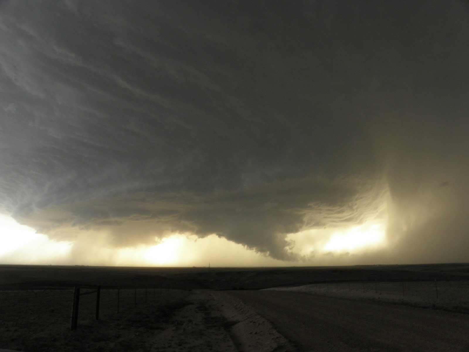
Long: We started the day in the hotel in northern Oklahoma City. We knew it was a potent set-up, with very juicy air continuing to be advected from the south, and a glancing blow from an upper trough moving in from the west. At the surface, a slow-moving SW-NE orientated cold front was to our north-west, and to the west, a dryline would mix in. The initial target area was somewhere west or south-west of Oklahoma City, so we headed to El Reno for lunch. Whilst there we sampled the atmosphere and noted dew points (a measure of the moisture, and thus, latent heat) of around 24C/75F. This is about as juicy an airmass as I've ever been in. I'd mentioned earlier that the day had a slight feeling of May 22, 2011, the Joplin tornado day, about it: that is, reasonable deep layer shear but not excellent low-level shear - but with extreme instability, which would more than make up for the slight lack of low-level shear.
As we finished lunch, a tornado watch with enhanced wording (a Particularly Dangerous Situation) was issued. By this stage, surface winds were starting to back to the south-east a bit, probably due to lift from the approaching upper trough and also lower pressure to the west due to intense surface heating west of the dryline.
Cumulus clouds were all about us, but on the satellite imagery we noted enhanced cumulus growth to our west and south-west. We decided to top off the fuel tank of the car and dropped south of town to get a better look at things. Towering cumulus clouds were developing to our north and north-west, although these seem to struggle with the capping inversion. We then saw more robust development to our west and this soon became a thunderstorm. It then quickly became a severe thunderstorm, and we headed a little west to afford a better vantage point.
Cloud to ground lightning was becoming frequent to our north, in the core and just on the downwind side of the updraught column. A pronounced rain-free base developed to our west and so we decided to head a little west to have a closer look. Rather quickly the storm *appeared* to become somewhat outflow dominant, with low-level clouds starting to race south-eastwards from the storm. We stopped for a look, but I soon became concerned that the clouds seemingly racing out in outflow were actually due to an rapidly intensifying low-level circulation. A ragged wall cloud formed to our north-west so we headed east. From this point on, it becomes a little tricky to recall exactly what happened. A tornado developed, which was multivortex, and we stopped a couple of times, briefly, to document it. However, the surging RFD seemed to accelerate the forwards progression of the tornado and so we had to race eastwards on dirt roads to keep ahead of it. Rain curtains were rapidly circulating just to our south-west, although, on reflection, and having a better clue as to where the tornado went, these curtains were probably more benign than they seemed at the time.
Somewhat in common with other large/strong tornadoes, this one took a sharp left turn towards the end of its cycle, and this took it into southern parts of El Reno. Tragically, several people were killed by this tornado, at least several in cars.
We then headed south in an attempt to move away from the storm, as it began to take more of a south-eastwards path. We noted another tornado close to Mustang before we continued south. At this point we ran into some horrendous traffic, because a huge number of people decided that it was safer to drive out of Oklahoma City, and get stuck in a traffic jam, than to ride it out. This resulted in a fairly worrying period of time for us as we knew a new circulation was forming to our west-northwest.
After some interesting driving exercises we navigated down a number of side roads away from the jam - this is where having a degree of situational awareness and also a good GPS mapping program works a treat.
Needless to say, once we got out of it all we paused to regain our composure and let the adrenaline ease. It was probably the scariest chase we've been on, and perhaps one of the scariest things we've done. Looking back, we were not in as much danger, thanks to anticipation of what the tornado was going to do, than we might have thought at the time. A number of other chasers seemingly hung around too long, or got caught out by how quickly the tornado span up, and several had damaged cars, and even some minor injuries - hopefully they are all OK.
We headed quite a way south and west, and have ended up in Lawton, Oklahoma, for the night. We spoke to one woman in the lift, from Yukon, Oklahoma - a town in the path of the storms. She had left town and travelled down here for the night - no doubt, one of the thousands on the roads fleeing the storm.
It was extremely worrying to see the thousands of cars on the road as this storm barrelled in - the tornadoes of May 19th and 20th have clearly, and understandably, left a huge impression on the population - today was much vaunted, with plenty of coverage - some of the news coverage certainly would have left the residents in no doubt that a huge storm was coming - perhaps too much? Who knows - this storm will certainly be the point of discussion for a long time to come, especially in regards to the reaction of the population of the Oklahoma City metro area.
I think this is our 6th or 7th chase day in a row - we're certainly in need of a break so we won't be chasing tomorrow. I think the next chance may be Monday, hopefully on the wide open High Plains - chasing close to Oklahoma City is something we probably won't do again, even if, in this case, we were never actually that close to the city.
A few pics from today - all copyright Helen Rossington/Paul Knightley:

Me awaiting initiation of storm - those clouds on the right of the picture are the beginnings of the devastating storm.

A look to the south, across a wheat field.

Developing supercell, a little west of the previous images.

Rain-free base starts to develop and storm intensifies.

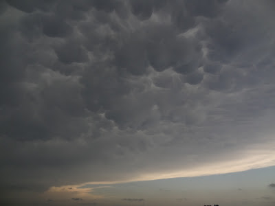
Very picturesque mammatus clouds above.

Me filming a rapidly developing multi-vortex tornado, south-west of El Reno, Oklahoma.

Same.

Large, wedge tornado near El Reno, Oklahoma - the tornado is the lighter cloud in the centre of frame.
Wedge tornado
Just finished dinner...will write this up when we get back to motel. Saw a multi-vortex wedge tornado today before having to escape to the east and south - probably the most intense chase of my life and a scary experience.
Friday, 31 May 2013
Awaiting
Currently we're just south of El Reno, watching storms trying to form to our north and west. The atmosphere is extremely volatile and strong tornadoes are possible later.
El Reno for lunch
Currently in El Reno about to have lunch. Will probably dry south a bit from here. Very moist atmosphere today, topped by steep lapse rates. Explosive thunderstorm development likely later this afternoon, and the instability and shear combination is expected to bring giant hail, and perhaps strong-violent tornadoes. Take care everyone.
May 31st thoughts
Hello. A rather volatile situation may unfold across central Oklahoma this afternoon and evening. Very moist low level air topped by steep mid-level lapse rates should allow for strong to extreme instability across the moist sector by mid to late afternoon. Shear will be sufficient for supercells to form rapidly after initiation with hail to over 4 inches in diameter likely.
The tornado threat is there too, especially into the evening hours as low level shear starts to increase. Although the low level shear is not very high, the instability should compensate and may allow for strong tornadoes to develop. Unfortunately it is central Oklahoma in the firing line once again, so we can only hope that any tornadoes keep away from populated areas.
Initial discrete development should be on the dryline by late afternoon so we'll likely head west or southwest of Oklahoma City.
May 30th
A long drive from Hays today but we got onto a good looking storm near Guthrie, although it didn't take long to go outflow dominant, likely due to the light surface winds. Now in a motel in NW Oklahoma City.
We knew that it was a long drive to get into the risk area, and that points south of Oklahoma City would likely have the higher storm chances. Given the traffic issues around the devastated Moore area we didn't want to pass south through the metro area.
Friday looks like being another volatile weather day for central Oklahoma, unfortunately. Once again the Oklahoma City area is in a risk area for severe thunderstorms including tornadoes, some of which could be strong, especially into the evening hours.
Here is the Guthrie storm displaying a brief, disorganised wall cloud, before the outflow undercut it and it turned into a shelf.
Thursday, 30 May 2013
May 30th thoughts
Fun trying to work out where the highest chances of severe convection are today. The models suggests S Cent Kansas and northern/central and eastern Oklahoma. However they don't yet have a handle on the outflow boundary sagging into N Oklahoma at the moment, which will likely lift northwards a tad as a pseudo warm front through the day. Somewhere along the I35 corridor as a starting point seems like a plan, so we'll be heading towards Wichita and points south, and re-evaluating en route. Good luck and stay safe today!
May 29th
A quick report. We headed from Salina all the way west to north of Dodge City. A lead upper trough had caused storms to form quite early and they formed into a line. We waited to the north-west of these to see whether any surface based storms would fire. One did but by the time we intercepted it, it had fizzled. We did get some storms out to the west which formed on the dryline west of Scott City. A nice shelf cloud developed and we then headed east with it following us. It made some nice outflow clouds which saved the day from being a total bust. It was nice to be out in the Kansas countryside, regardless.
We headed to Hays for the night. Further thunderstorms are developing as the low level jet rides up over the outflow from the earlier storms. As I write this, lightning is flashing outside with booming thunder...nice!
Tomorrow looks like bringing another round of severe thunderstorms, with parts of south central Kansas and northern Oklahoma being in the firing line for some potential significant weather.
Wednesday, 29 May 2013
May 29th thoughts
Hello. A quick post as we're about to leave Salina. We're heading south-west towards the Dodge City area although will evaluate en route. A moderate risk of severe thunderstorms is in place today with some impressive parameters likely to develop through the day. Strong instability and shear will juxtapose across a wide area today and storms will likely become supercells quickly. Any supercell poses the risk of very large hail, along with a wind and tornado threat. The highest chance of tornadoes may be this evening as the low-level jet starts to pick up, especially across parts of SW and S Cent Kansas, and adjacent parts of Oklahoma. There is the risk of a strong tornado.
May 28th - wedge tornado
Hello. We started the morning in Salina, Kansas. We had to call the rental car company in order to try to sort out a replacement. We headed across to the local office by 9am, which was an early start after our late night! They tried to get a repair shop to look at it initially, which we had to drove to, but the guy there said he wouldn't touch it because it's still under warranty. So it was back to the rental office. They said we could swap it for another, but the only two they had available were fairly small - thus we've kept the one we had, and will just make sure we fill the fuel tank fairly often, to make sure we're happy we have enough fuel!
Anyway, onto the chase. After heading back to the motel we checked out just after midday. We headed for a gas station and fuelled up. We wanted to hang close to a fairly slow-moving frontal boundary and its intersection with a rather poorly defined dryline to the south-west of an area of low pressure, which was located in central Kansas. We decided to head west and then south to Ellsworth, Kansas, which was close to the junction of these features. We had lunch at Subway and waited. After a little while it became apparent that the drier air was approaching and that we'd need to head back east towards Salina. At this time, several towering cumulus clouds formed very close to our location. After about 15 mins or so we paused on our eastward journey, almost underneath the most vigorous tower. It was already starting to rumble with thunder, so we continued to head east. We passed Salina, and then headed north, through Niles. We then looked back to the west and saw the storm beginning to get much more organised, and it soon took on supercellular characteristics.
A while later the rain free base became better defined and then, fairly quickly, two funnel clouds developed. We believe that one was a tornado as someone did report a brief one - it was interesting as these seemed to not be directly tied with the mesocyclone, or perhaps formed before any real RFD developed.
We headed a little further north and found another vantage point. At this stage the low-level mesocyclone was rather wrapped in rain, but after a while a large tornado became visible within the rain. This was about 6 miles to our west. The rain cleared away for a time and afforded us a fairly good view of the large, wedge-type tornado. The rain then wrapped back around, but we got occasional glimpses of the almost 1 mile wide tornado. The tornado was actually there for about 40 minutes, and hardly moved at all. Some chasers were much closer and got some pretty amazing pictures and video, but our view was good enough.
When the mesocyclone became completely rain-wrapped we dropped south and then west, and then north, to try to look inside. It was just too wet by then to navigate into the low-level circulation area safely, so we broke off, and headed back to Salina. We're back in the same motel as last night, albeit in a different room.
It was great to be on the storm from its inception - we were pretty much right under the point where it started to develop. I think that we could have jumped north and got the closer shots, but we did end up with some very nice shots of the structure of the storm, and the tornado.
Here is a timelapse from the Go Pro

Here is the developing storm as viewed from a position next to I-70, to the NE of Ellsworth, Kansas.

Here is the initial funnel/tornado - we got a report in about this to Spotternetwork.

Here is the large tornado to our west - you can see it almost in the centre of shot, especially when you click on the image to enlarge it.
Tuesday, 28 May 2013
May 27th
Got on to an OK storm close to Osborne but the biggest cell of the day was further north, across areas we'd driven through earlier on. It did look reasonable from other people's pics but the tornado was only seen by a few.
Our storm briefly showed some supercell characteristics but a new one formed to the south so we got onto that. It was rather multicellular but did have a pseudo RFD for a short time, around sunset, so it looked pretty.
We left it as it started to fall apart and drove to Salina, where we're staying the night. We ate dinner at Applebee's with Pete Scott, Steve Lansdell, Nathan Edwards, and Dave Ewoldt.
We also saw Will Owen, a Kiwi chaser we met last year, and I've known for a while from Stormtrack and Facebook. He's chasing with Rebekah LaBar, who we met today too.
Today's highlights were killing an amorous pigeon as it jumped another one just in front of the car. Car 1 Pigeon 0, sadly. Then, listening to various American brats murdering songs in Applebee's. My ears were truly bleeding and I suspect it is some kind of payback for the pigeon incident. Finally, Helen enjoyed a Big Boy at lunchtime.
We're going to attempt to get the car's fuel gauge working tomorrow morning via the hire company.
Monday, 27 May 2013
Osborne, Kansas
Just south of Osborne, Kansas. A moderate risk of severe storms including tornadoes this afternoon and evening. We're positioning north-east of a surface low, close to a warm front.
May 26th - a beautiful supercell!
Drove from Colby to McCook, and thence to North Platte, Nebraska. Not much happened for much of the day but we caught up with our storm chasing buddies Pete Scott, Steve Lansdell, and Nathan Edwards. We spent an hour or more getting sunburnt before noticing a storm starting to form to our east. We went our separate ways.
We caught up with the storm east of Broken Bow, Nebraska, and it turned into a gorgeous supercell storm. The fellas also got onto this and got some stunning pics - we got a few too, shown below.
We then headed south and east to Kearney for the night, and met up with the fellas at Applebee's for dinner - great times!
The only annoyance was running over something (perhaps a piece of metal) on our way to Kearney which pulled a wire connector out under the car (why it's put in such a stupid place I don't know!). This appears to be a wire which tells the dashboard how much fuel to say there is. I put the connector back in its slot but one of the wires has come astray and I couldn't get it to go back in. Tomorrow morning we'll try again, and attempt to bare the wire a bit before putting it in. If that doesn't work we'll be on the phone to the hire company again! The car works fine, we'll just have to make sure we fill up with fuel every so often, before it gets low!
Pics below show the supercell (from the Go Pro) as we approached it from the west, and then 3 exposures in an attempt to capture some lightning.


Sunday, 26 May 2013
May 26th thoughts
Hello. We're still in Colby at the moment. Today a surface cyclone to the west will draw moisture north and then north-west around it, with a dryline mixing slowly eastwards to its south. Somewhere east or north-east of the low should be interesting. Once again, the best backed flow appears to be across western Nebraska but we're not going to head that far. We're thinking somewhere north-east of Colby, for example Oberlin to Norton, might be a reasonable play later this afternoon.
Storm chances remain across the Plains for much of the coming week too, perhaps with an upturn in severe potential for the middle of the week. Even so, we're taking this day by day and not worrying much about the next few days yet.
Storm chances remain across the Plains for much of the coming week too, perhaps with an upturn in severe potential for the middle of the week. Even so, we're taking this day by day and not worrying much about the next few days yet.
Pleasant day's chasing
Hello. We started the day in Garden City, Kansas, and after perusing the models and observations decided to head north to Oakley. We had lunch there and carried on looking at the weather. It was clear that the highest chance of supercell thunderstorms was too far north to reach in a reasonable time. However, a deepening surface low and backed flow ahead of it, coupled with an advancing dry line gave a hint that a few storms might form closer to us. We headed west to Colby and had a coffee/frozen strawberry lemonade. We also Skyped my Dad, and my cousin, who was there. A storm started to develop to the west, near Goodland. We headed west a bit and then dropped south. We then spent much of the afternoon and early evening watching the almost stationary cell to our west. It was putting out occasional CG lightning and there was a constant rumble of thunder from within the storm due to cloud-cloud lightning. It was fairly picturesque but although showing occasional supercell characteristics, the lack of decent deep layer shear precluded a more sculpted storm. Even so, the fact we could just sit there and watch a storm for several hours without moving much was very nice indeed.


.JPG)
We're staying the night in Colby, Kansas, and ate dinner at Montana Mike's. Tomorrow looks like bringing the risk of isolated supercells again across the western Plains - anywhere between here and SW Nebraska looks good - indeed, a surface low in parts of SW Nebraska probably makes that area down towards the Kansas border a reasonable play. Monday may bring a reasonable risk of severe storms and perhaps tornadoes to parts of central and north-central Kansas.
A few pics and video grabs below.

The car, at Oakley

Lightning to the east of Goodland

And again

Car and storm

Storm

Storm

Mammatus above motel, in Colby
.JPG)
View from motel car park
Saturday, 25 May 2013
Oakley
Hello. A slight risk of severe storms over a very broad area today. The highest chance looks to be up in parts of Montana, South Dakota and western Nebraska. Having started the day in Garden City we've stopped for lunch at Oakley, Kansas. We're still trying to decide where to head to - even this area could get a severe storm but the higher chance looks to be around SW Nebraska - at least, a higher chance in an area we can get to in a reasonable time. We're probably going to head to Ogallala in Nebraska and take it from there, as a slightly backed surface flow should be in that area, north of a deepening surface low pressure in NE Colorado.
To Garden City
We made a Skype phone call to Helen's Mum as it was her birthday (Happy Birthday!).
We had dinner at Applebee's this evening, just for a change! I had the sizzling fajitas - yummy!
Just now as I write this the southerly wind (return flow, as it's known) is howling around the building. A bit noisy but it always carries with it the thought of storms, as it is returning moisture northwards.
Tomorrow looks like a chance of storms across parts of the High Plains - we'll have a look in the morning. The longer range indications into next week seem to increase the risk of severe storms in the central USA as a powerful jet and trough move in from the west - too early to pinpoint days and locations but the overall pattern looks rather active for a time.
Here's this evening's sunset, as viewed from outside the motel.

Friday, 24 May 2013
A memorable chase, but not for the right reasons!
We started the day in Childress and hung around until early afternoon. We started to head west towards Estelline and then dropped south towards Turkey. A storm had fired to the south-west of that area. There were reports of occasional weak spin-ups underneath the storm so we moved into a position to look at the updraught. We'd dropped south to Matador, and then west/south to near Dougherty.
However, the dry conditions in this part of the Panhandle made the inflow, and outflow, very dusty indeed. It was very hard to see much of the updraught base for much of the time due to the dust.
We continued to drop southwards to keep ahead of the storm - plenty of very local whirls were occurring along the leading edge of the outflow which looked pretty cool as they spun the dust up. A new wall cloud attempted to organise close to us. We carried on to the south.
We reached highway 82 east of Crosbyton and paused briefly just off the road to watch the dust again, facing south. After a few minutes the wind started to pick up and 'jets' of dust started to race past from the north. Suddenly a wall of black enshrouded the car and the wind increased to probably 70-80mph. This lofted stones from the edge of the road and threw them into the back of our car, smashing the back window and two side windows (one by the back door and the one by the boot on the driver's side). A stone came into the car with such force it chipped the inside of the front windscreen. Luckily we were both uninjured, although pretty shook up!
We had to get away from the storm so took quite a protracted run to the south and then west to Post, Texas. As we pulled up at the McDonald's (somewhere to have a pee!) the manageress came out and asked us if we were OK, and gave us a sack to put some of the glass in. Then a chap appeared who owned the business next door and said he could cover up the broken windows with some kind of sticky plastic stuff (a vinyl type thing) - we accepted his kind offer and drove the car into his workshop. He did a sterling job and wouldn't accept any cash, despite my best efforts to pay him - what a star!
I called the rental car company and they arranged a new car for us at Lubbock, which we picked up. We're now in the Sleep Inn, having had dinner at Applebee's.

The dust storm about to envelop us - note the extreme darkness in the wing mirror.

Just 3 seconds later, and we're engulfed.

The Go Pro's view of the departing wall of dust which had just blasted us...maybe a microburst? Whatever it was, it was powerful.

The car in the chap's workshop who patched it up for us. Fat Cat Graphix is the name of the business.
Thursday, 23 May 2013
Latest thoughts are that we're in a pretty good position here in Childress. The outflow boundary/front is pretty close by and various models hold it close to this area through this afternoon, with moisture pooling along the feature. East or south-easterly flow moving upslope along with a subtle upper feature approaching from the west should allow the cap to be broken in places. The backed flow on the cool side of the boundary should yield lower cloud bases and reasonable low-level vorticity - the tornado risk should be highest here.
The image below is from the 12Z HRRR model, showing dewpoint at the surface. The depiction is fairly similar to other models - it seems to have a reasonable handle on the boundary. Also, a dryline may mix in from the west in the afternoon - I've highlighted these boundaries and also a prelim target area. Previous experience also suggests that the Silverton-Turkey area is one area where storms 'like' to form in upslope flow, although, as always, refinements will take place as the day goes on.

The image below is from the 12Z HRRR model, showing dewpoint at the surface. The depiction is fairly similar to other models - it seems to have a reasonable handle on the boundary. Also, a dryline may mix in from the west in the afternoon - I've highlighted these boundaries and also a prelim target area. Previous experience also suggests that the Silverton-Turkey area is one area where storms 'like' to form in upslope flow, although, as always, refinements will take place as the day goes on.

May 23rd initial thoughts
Currently still in Childress looking at data etc. A reasonable risk of supercells today especially where any storms interacts with an outflow boundary/pseudo cold front. Think storms should form on the Caprock amidst 4000J/Kg instability and then move into deeper moisture. Will need to be close to the boundary as a fairly hot boundary layer will mean fairly high cloud bases away from it. Big hail the main threat but tornadoes a possibility close to the boundary.
To Childress
Hello, chase fans! Today we drove from Corsicana to Childress, Texas. It was approximately 300 miles, and we arrived here early evening. It was a stunning north Texas day, with pretty much clear blue skies and a high of around 34C. It was a fairly dry airmass too so it felt very pleasant. We had to negotiate central Dallas but the freeway system meant that it was fairly free moving apart from the odd slow patch.
We had lunch in Rhome, and then stopped for coffee/frozen strawberry thing (the latter for Helen) at a Maccy Ds in Iowa Park (near Wichita Falls).
We've headed up this way as Thursday brings a risk of severe storms to the Texas Panhandle region. A moist south-easterly flow will pick up overnight and a slow-moving frontal boundary will be in the area. A dry line will likely be across western parts of the Panhandle. Storms may form on the dryline but perhaps more likely close to the front, especially close to the Caprock escarpment, where terrain-forced ascent may help updraughts build into thunderstorms. The upper flow will be fairly weak, but a sharply veering wind profile in the lower layers, coupled with deviant motion of any storm interacting with the boundary should be sufficient for supercells capable of large hail. A tornado is possible close to the front, although the storms may grow upscale into a small MCS as they move south-eastwards along or just north of the front. The thread would then be more of a damaging wind one.
We'll refine our target in the morning but I suspect it won't be too far west or north-west of here.
Wednesday, 22 May 2013
Luncheon
Hello. We're heading north-westwards today, probably to Childress, Texas. We've successfully negotiated Dallas and are now heading NW on US 287. We've stopped for lunch in Rhome. No storms today - indeed, it's a beautiful north Texas afternoon with temperatures around 30C and clear blue skies. Tomorrow, a moist SE'erly upslope flow may set the stage for at least isolated thunderstorms across portions of the TX Panhandle, especially around the Caprock. Sharply veering wind profiles may support supercells before the activity possibly grows slightly upscale as it moves SE into the surface flow. Modest flow aloft should mean slow-moving storms.
First chase day
Short: Chased a line of storms which were outflow dominant. Heavy rain and lightning, and gusty winds, were the highlights.
Longer: Started the day in Weatherford after a well-needed sleep. Headed across to Walmart - Helen went and got some supplies whilst I set up the various equipment in the car. Seemed to take forever to get the GPS for the Baron system, etc, to be discovered, but in the end it was and we could start. By this time, outflow from storms to the north pushed down from the north-west, and this became the effective cold front through the day.
We headed east and then south, the latter on I-45. We stopped in Fairview for lunch, by this stage out of the storms. Thunder boomed to the north-west, but the skies ahead remained stubbornly cloudy. Even so, temperatures were around 30-31C with 21C dewpoints, so it was very juicy and potent air.
We continued south to Buffalo, and then south-west to Marquez, as a storm, which had remained reasonable discrete, was approaching. However, it got undercut by the advancing colder air, although some broad low-level rotation was evident on radar for a time. We were in a good spot in case anything brief spun-up but nothing did. After playing in some gusty winds, close lightning, and torrential rain, we headed back north. We've ended up at Corsicana for the night.
All in all a nice first day with thunderstorms - OK, so not supercells but we're happy enough to have seen some storms on the first chase day.
Below is a grab from my video camera of some lightning.
.jpg)
Tuesday, 21 May 2013
Fairfield
Just stopped at Fairfield, Texas, to take stock. A severe storm is to our WSW moving in this general direction although it is likely to be overtaken by the advancing cold front/outflow boundary. Even so we'll hang around to see what it's like as there's not much else going on. It's cloudy and 31C with a dewpoint of 21C, so it's pretty sticky!
Raining!
In the Walmart carpark at the moment in Weatherford - gusty winds and heavy rain now. Took a long time to get all the stuff working on the laptop but it's OK now - looks like the outflow/cold front is already starting to surge south-eastwards so discrete development may not be so likely now - indeed, at the moment it already looks like turning into quite a line of storms - we'll try to get south-east of it but it doesn't look so great just now.
Time to chase
Currently in Weatherford, Texas, after a well-deserved sleep. Shortly we'll depart, get stocked up at Walmart and set-up the stuff in the car. Then it's time to chase. A moderate risk of severe thunderstorms today - initial discrete development should turn more into a line through the afternoon. Initial target close to Breckenridge but will refine through the remainder of the morning.
Arrived - after a fashion, and some terrible damage elsewhere in the Plains
The majority of our trip across the pond to the USA was uneventful - we boarded on time, left pretty much on time, and landed fairly on time. Then it took 3.5 hours to get through passport control - Dallas Fort Worth airport clearly does not care much about arriving passengers!
This was clearly an annoying situation but pretty much as soon as we'd landed and I'd got my phone on I started getting word about the unfolding tornado tragedy in Moore, Oklahoma. This place has been affected several times by intense tornadoes, perhaps most famously on May 3, 1999, although May 20, 2013, is now sadly going to go down as, perhaps, an even worse event.
As we cruised south-eastwards across the Missouri Valley area we noted intense cumulonimbus development to our north-west and west. I don't know the exact evolution of the events of the day but I *think* the image below shows the Oklahoma City storm. The image below shows our position at that moment. The third picture is another huge cumulonimbus which was south of the first one.


We then got to our car pretty quickly - we have a Chevy Traverse again, same make as last year!
We headed west to Weatherford, observing a thunderstorm to our west - this produced some pretty impressive lightning, which was pretty cool to see on our first day.
It also produced some mammatus (seen from the edge of DFW airport in the pic below).
After getting to Weatherford and after the clerk located our in-car wifi package, which had been delivered to the hotel on Friday and then put in a safe location, we headed to Applebee's for some dinner. Now it's bed time, as, for us, it's 5.28am and we've been up for almost 24 hours after only 3 hours' sleep the night before!
Tomorrow brings a moderate risk for severe thunderstorms over parts of Texas. We'll choose a chase target in the morning, but we also need to sort the Baron system out and pick up some supplies from Wal*Mart.
Pic below = mammatus.

Monday, 20 May 2013
Time!
Just a quick post. We're just doing the final little bit of packing etc and then we're off to the airport. Next stop Dallas!
Sunday, 19 May 2013
Gearing up!
Time to start packing! As always it's impossible to not look at charts for the coming weeks even though experience has told me that what looks like happening now probably won't by the time we get into the trip! Even so, thoughts below!
A risk of severe storms when we arrive in Dallas tomorrow, and then perhaps central TX on Tuesday. Mid to late week sees a ridge start to build but moisture looks to remain fairly extensive so some local areas of severe storms possible, esp before the weekend, as the flow remains marginally supportive. Could be some upslope chances. Then the ridge may cap if off for a while before a chance of the westerlies developing next week, especially in the northern half of the Plains.
Friday, 17 May 2013
Getting closer
In just a few days time we'll be heading across to the USA for our 2013 storm chasing trip. Sadly, the last 48 hours has brought some powerful and deadly tornadoes to portions of the USA, namely north Texas. The region to the west of the Dallas-Forth Worth metroplex was hardest hit. It was a day where severe storms were expected but the coverage was likely to be fairly low, and this turned out to be the case. For those of you who read this and wonder what I'm on about when I speak of the Storm Prediction Centre's risk levels of Slight, Moderate, and High, those risk levels are to give an indication of the overall coverage of severe storms. Thus, a slight risk does not mean that storms will only be slightly severe, etc, it just means that they are not expected to be numerous and/or especially widespread.
The environment was one where rich tropical moisture had spread in from the Gulf of Mexico and a disturbance in the upper air was moving in from the south-west. As evening approached, winds in the lower atmosphere became much more favourable for low-level rotation, which aided in tornado development. One large tornado took a sharp left turn late in its life, which seems to be something bigger/more powerful tornadoes are want to do. This is something chasers should bear in mind.
The risk from severe storms increases this weekend as a large scale upper trough moves in from the west and Gulf moisture moves northwards. However, the strong SW flow aloft will advect some very warm air eastwards atop the Gulf moisture, providing a strong capping inversion. Across the southern Plains on Saturday this could prevent storms from forming but further north, lift from the approaching system should cool the air aloft enough to erode the cap. Any storms which form will do so in a region of strong vertical wind shear, and will likely be severe - very large hail the main threat although with deep Gulf moisture in place, tornadoes are possible too, perhaps more likely in the evening as the cloud bases drop and the low-level jet cranks. Sunday and Monday also look like bringing severe weather - hopefully residents will be aware as the season has been very quiet thus far and a false sense of security may have crept in.
Several UK chasers are already there, along with many others from around the world, including Australia. This is in addition, of course, to the US chasers. Watching the developments this weekend from here in the UK will just add to my desire to get out there! Next week should see the trough easing eastwards into the central USA as a closed low, before it opens again and drifts further east. Beyond that, a new trough moves into the west but models can't then agree about downstream developments. It does look like a ridge will try to form in the central USA at least for a time, but some models, e.g. the GFS, have trended to a flatter ridge. I suspect the closing days of May may well see a general westerly flow established.
Severe weather should be less widespread into the middle of next week but still possible, especially across the western Plains as an easterly upslope develops beneath a modest westerly. This could yield some picturesque storms over open country.
Of course, this is all an age away meteorologically speaking - however, it doesn't look like, at this stage, a strong cold front will barrel into the Gulf of Mexico, so moisture will be in place across the Plains.
Tuesday, 14 May 2013
Ramping up to departure!
Hello! It's beginning to feel a lot like....no, not Christmas, but the time of year when we head over the pond to the USA, for our annual storm chasing holiday. There are good and bad points about having to do it the pre-booked way: the obvious bad point is that we're at the whim of the weather, and its fickleness. Those who have the luxury of being to make a last minute choice before heading over can pick and choose as weather systems dictate. Of course, that could mean not going at all, or having to make a fairly crucial decision about whether to go, as you never know whether the next system might be more productive.
The good thing about going at a fixed time it lends itself perfectly to being a proper holiday, and gives us something to look forward to. OK, so we're at the weather's whim, but so what? There's plenty of other stuff to do, and it's (almost, touch wood!) unheard of to go for 2 weeks and not see anything. This year has, though, been extremely quiet on the severe weather side of things in the USA. Of course, fundamentally this is great news for the residents - storm chasers have been climbing the walls, though!
There is a more active weather pattern setting up later this week and into the weekend as a trough moves in from the Pacific, and sharpens as it enters the Plains. The image below depicts 500 hPa heights and winds for 00Z Sunday (1900CDT Saturday), from the excellent http://weather.cod.edu site

Notice the powerful jet nosing into California, and the trough to its east. This jet should start to collapse into a more pronounced trough through Sunday and into early next week, as it moves eastwards, eventually becoming a closed low towards eastern states, although the eventual outcome is not clear at the moment.
Lower down, the mass response will be a southerly 'return flow' bringing rich Gulf moisture into the Plains. The stage is set for several days of severe weather, especially from the central Plains into the mid-Missouri valley, and then perhaps points further east.
Those chasers already there or about to head out will no doubt be looking at this with interest. For those of us going next week, this is a situation to whet the appetite but also one which will likely make us feel we just missed!
The longer term outlook appears to favour, at least for a time, the development of a ridge across south-western and then southern states through next week. This is likely to be detrimental to severe weather on a regional scale. There appears to be a trend within ensemble products of the ridge flattening later in the week, with a faster flow in the upper atmosphere developing across central and northern states. With the indications suggesting that this weekend's system should not send a cold front crashing right through the Gulf of Mexico, moisture return may be able to commence from mid-week, especially across western parts of the Plains. This all depends, crucially, on where surface high pressure sets up, and whether or not ridging close to the Gulf coast prevents this flow.
Thus, severe storms look likely this weekend across the Plains and Midwest, and then probably further east and south on Monday, before quieter weather develops for a while into mid-week - a chance of storms may then return later in the week, but confidence obviously becomes very low by that stage.
For those of us who make it a holiday, there's always a Plan B, and C, and quite usually a D too! Keep tuned to this blog to see which plan we follow!
Wednesday, 8 May 2013
Subscribe to:
Posts (Atom)