Thursday, 6 June 2013
Home!
Hello. We've just got home from the USA. Happy to be home, sad to have left. The events of May 31st have left an indelible impression on us both, though.
Wednesday, 5 June 2013
Almost time to leave
Hello. We did most of our packing last night. Just a few bits to do this morning and then it's off to DFW for the flight home. It's been a full on trip this year with great memories and sad ones too. Certainly not one which will be forgotten.
Tuesday, 4 June 2013
June 3rd report
Short: Intercepted several storms in the Oklahoma and Texas Panhandles, culminating in a stunning supercell.
Long: We awoke in Amarillo, and I decided to dust off the Speedos and do a bit of morning swimming - annoying kids in the pool meant I only swam for a bit before my annoyance levels took me back to our room for coffee.
We left Amarillo around noon/midday/1200, whatever it's known as, and headed north towards Guymon, Oklahoma. We were targeting the Panhandle region, as moist upslope flow combined with weak lift from an upper system meant that scattered showers and thunderstorms should form, and then become severe as they moved east and south-east into somewhat moister air.

After lunching in Guymon, where it was 38C (!), we headed a bit north and east, to just east of Hooker, Oklahoma. We then spent a while watching convection try to form but having a tough time. My mood become a bit despondent with it all for a while but spirits were lifted as a storm to the north-west took on a more solid look (above shows me watching it starting to form). We headed north, and started to see CG lightning coming out. Here is a lucky shot I took (below).


Long: We awoke in Amarillo, and I decided to dust off the Speedos and do a bit of morning swimming - annoying kids in the pool meant I only swam for a bit before my annoyance levels took me back to our room for coffee.
We left Amarillo around noon/midday/1200, whatever it's known as, and headed north towards Guymon, Oklahoma. We were targeting the Panhandle region, as moist upslope flow combined with weak lift from an upper system meant that scattered showers and thunderstorms should form, and then become severe as they moved east and south-east into somewhat moister air.


A number of our UK storm chase friends were also on the storm, and turned up!

After a while we went our separate ways, and we headed east, to keep viewing the storm. However, it became clear that, whilst nice looking, it was going into a region where it would be tricky to keep following it by road, so we dropped south onto a new storm. We noticed on the Spotter Network that our friends Nathan, Pete, and Steve, had stopped, and the radar looked very interesting - we decided to drop down to see what had got their attention. It was a stunning supercell - we already had realised it was a supercell from the radar, but one look confirmed it. We pulled up next to them and spent quite a while in one place documenting it - this was south of Beaver, Oklahoma (below).
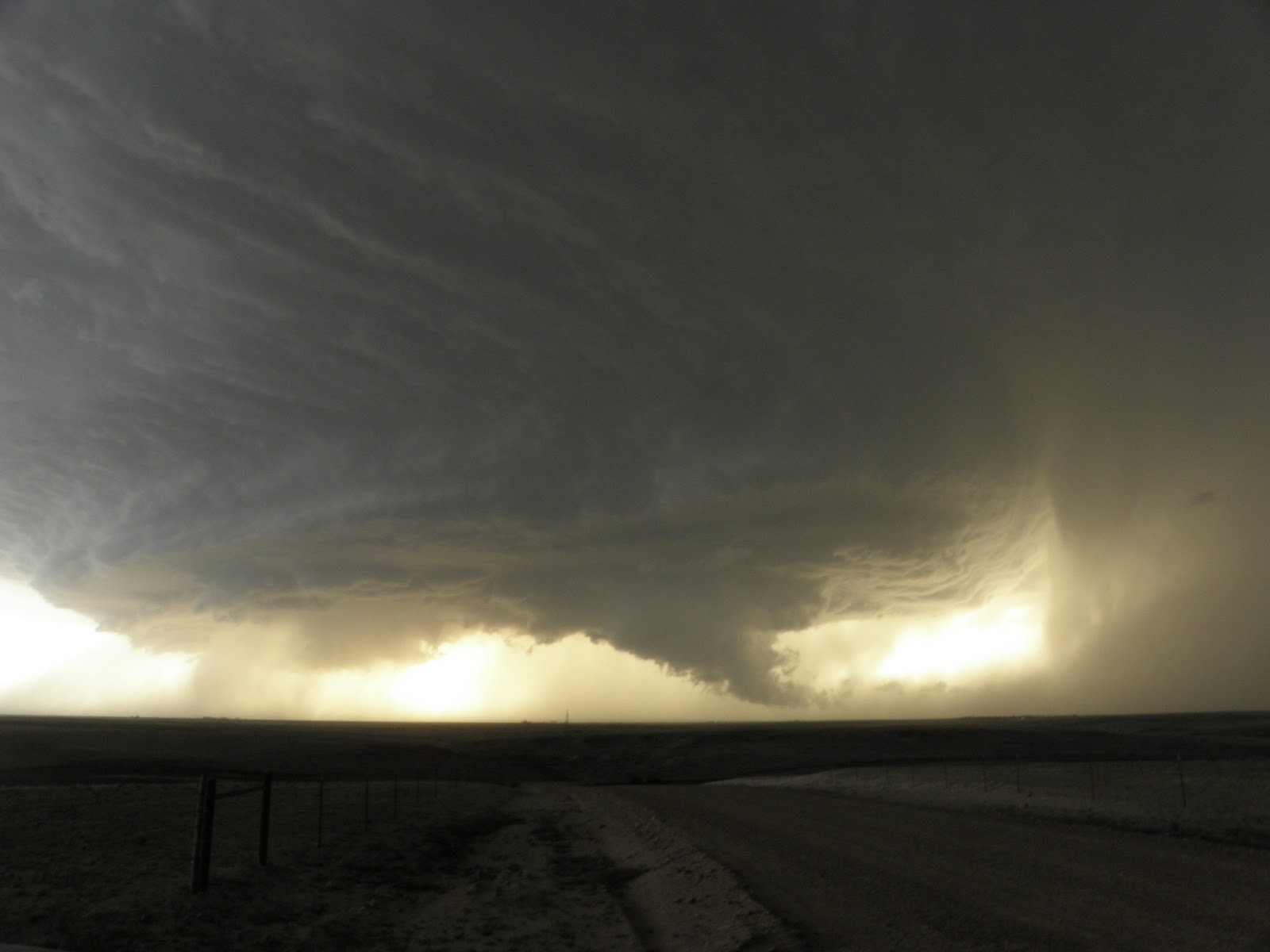
We then had to drop south, but stopped again to watch and document it some more (below). Soon it became apparent that we needed to get south and east before the angry RFD got us, so we headed down to Booker, where the sirens were sounding (the storm was warned for 80mph winds), and then east. After watching it some more we decided to leave it after dark, and we went our separate ways. Helen and I ended up in Elk City, and a brand new Sleep Inn. No places to eat though, so it was dirty microwave burgers and chips from Walmart! A far cry from the Big Texan last night! One more chase day tomorrow and then it's to Dallas on Wednesday for the flight home.

Monday, 3 June 2013
June 2nd - is this the way?
We decided we would head to Amarillo today as we didn't want to head miles south-westwards into New Mexico. It gave us the chance to do two things: visit the Palo Duro Canyon State Park, and eat dinner at the Big Texan Steak Ranch - these are both things that anyone visiting the Amarillo area should do.
Needless to say our minds were in a fair degree of turmoil following the tragic news I conveyed in a previous post - it was almost a continuous cycle for me, one of thinking it can't possibly be true, then realising it is, and then trying to accept it, and then again. And I didn't know them personally - I can't begin to imagine what those that do are going through.
The visit to the canyon gave us plenty of quiet time to enjoy the scenery and to take it in, and savour the moment. One must always savour such moments, indeed, all moments.
We spent a very pleasant several hours taking pictures, driving around, and getting out and enjoying the Texas sunshine - it seemed a million miles away from tornadoes and tragedy.
We then headed to Amarillo - trying not to have the infamous song going around in our heads - and then headed to the Big Texan, for a very nice steak. We saw Paul Botten, Tom Lynch, and their chase party and had a nice chat with them about everything that's happened recently.
Tomorrow brings a slight risk of severe storms across quite a large part of the High Plains. We'll pick a target region in the morning but far SW Kansas looks a possibility at the moment.
Sunday, 2 June 2013
To Amarillo amongst a tragic loss
We went to bed last night just as the news was breaking within the chase community that three of its most experienced and revered chasers, Tim Samaras, his son Paul, and their chase partner Carl Young, were killed in the El Reno tornado on Friday. Waking this morning made me hope it had been some awful dream but sadly it wasn't. The chase community has been shocked and stunned by this. Those with no clue about chasing will likely be quick to criticise what they deem as being a reckless and dangerous pursuit. Sure, getting close to a tornadic supercell is never going to be risk free, but these were people with masses of experience, and who were in it for the science as well as the fascination of being close to such a force of nature. We can only offer our sincere condolences to all their family and friends...we did not know them personally but within the chase community we obviously knew of them and their work intimately. RIP.
For us, today is a quiet day. We're heading to Amarillo and the Big Texan for dinner, but beforehand we're going to have some quiet time at the Palo Duro Canyon.
It has been a tough time to be a chaser but we have to continue doing what we love to do.
For us, today is a quiet day. We're heading to Amarillo and the Big Texan for dinner, but beforehand we're going to have some quiet time at the Palo Duro Canyon.
It has been a tough time to be a chaser but we have to continue doing what we love to do.
June 1st
We didn't do any weather type stuff today. We drove to Lubbock as there's a small chance of severe storms west and southwest of here tomorrow. It was a nice drive and it was sunny the whole day! We saw a couple of dust devils and stopped at the place where our windows got blown out earlier in the trip, just to see what it looked like outside a storm.
Saturday, 1 June 2013
May 31st report
Short: Intercepted a large multivortex wedge tornado near El Reno, Oklahoma. Had to get east and south out of its way, but traffic was horrendous.
Long: We started the day in the hotel in northern Oklahoma City. We knew it was a potent set-up, with very juicy air continuing to be advected from the south, and a glancing blow from an upper trough moving in from the west. At the surface, a slow-moving SW-NE orientated cold front was to our north-west, and to the west, a dryline would mix in. The initial target area was somewhere west or south-west of Oklahoma City, so we headed to El Reno for lunch. Whilst there we sampled the atmosphere and noted dew points (a measure of the moisture, and thus, latent heat) of around 24C/75F. This is about as juicy an airmass as I've ever been in. I'd mentioned earlier that the day had a slight feeling of May 22, 2011, the Joplin tornado day, about it: that is, reasonable deep layer shear but not excellent low-level shear - but with extreme instability, which would more than make up for the slight lack of low-level shear.
As we finished lunch, a tornado watch with enhanced wording (a Particularly Dangerous Situation) was issued. By this stage, surface winds were starting to back to the south-east a bit, probably due to lift from the approaching upper trough and also lower pressure to the west due to intense surface heating west of the dryline.
Cumulus clouds were all about us, but on the satellite imagery we noted enhanced cumulus growth to our west and south-west. We decided to top off the fuel tank of the car and dropped south of town to get a better look at things. Towering cumulus clouds were developing to our north and north-west, although these seem to struggle with the capping inversion. We then saw more robust development to our west and this soon became a thunderstorm. It then quickly became a severe thunderstorm, and we headed a little west to afford a better vantage point.
Cloud to ground lightning was becoming frequent to our north, in the core and just on the downwind side of the updraught column. A pronounced rain-free base developed to our west and so we decided to head a little west to have a closer look. Rather quickly the storm *appeared* to become somewhat outflow dominant, with low-level clouds starting to race south-eastwards from the storm. We stopped for a look, but I soon became concerned that the clouds seemingly racing out in outflow were actually due to an rapidly intensifying low-level circulation. A ragged wall cloud formed to our north-west so we headed east. From this point on, it becomes a little tricky to recall exactly what happened. A tornado developed, which was multivortex, and we stopped a couple of times, briefly, to document it. However, the surging RFD seemed to accelerate the forwards progression of the tornado and so we had to race eastwards on dirt roads to keep ahead of it. Rain curtains were rapidly circulating just to our south-west, although, on reflection, and having a better clue as to where the tornado went, these curtains were probably more benign than they seemed at the time.
Somewhat in common with other large/strong tornadoes, this one took a sharp left turn towards the end of its cycle, and this took it into southern parts of El Reno. Tragically, several people were killed by this tornado, at least several in cars.
We then headed south in an attempt to move away from the storm, as it began to take more of a south-eastwards path. We noted another tornado close to Mustang before we continued south. At this point we ran into some horrendous traffic, because a huge number of people decided that it was safer to drive out of Oklahoma City, and get stuck in a traffic jam, than to ride it out. This resulted in a fairly worrying period of time for us as we knew a new circulation was forming to our west-northwest.
After some interesting driving exercises we navigated down a number of side roads away from the jam - this is where having a degree of situational awareness and also a good GPS mapping program works a treat.
Needless to say, once we got out of it all we paused to regain our composure and let the adrenaline ease. It was probably the scariest chase we've been on, and perhaps one of the scariest things we've done. Looking back, we were not in as much danger, thanks to anticipation of what the tornado was going to do, than we might have thought at the time. A number of other chasers seemingly hung around too long, or got caught out by how quickly the tornado span up, and several had damaged cars, and even some minor injuries - hopefully they are all OK.
We headed quite a way south and west, and have ended up in Lawton, Oklahoma, for the night. We spoke to one woman in the lift, from Yukon, Oklahoma - a town in the path of the storms. She had left town and travelled down here for the night - no doubt, one of the thousands on the roads fleeing the storm.
It was extremely worrying to see the thousands of cars on the road as this storm barrelled in - the tornadoes of May 19th and 20th have clearly, and understandably, left a huge impression on the population - today was much vaunted, with plenty of coverage - some of the news coverage certainly would have left the residents in no doubt that a huge storm was coming - perhaps too much? Who knows - this storm will certainly be the point of discussion for a long time to come, especially in regards to the reaction of the population of the Oklahoma City metro area.
I think this is our 6th or 7th chase day in a row - we're certainly in need of a break so we won't be chasing tomorrow. I think the next chance may be Monday, hopefully on the wide open High Plains - chasing close to Oklahoma City is something we probably won't do again, even if, in this case, we were never actually that close to the city.
A few pics from today - all copyright Helen Rossington/Paul Knightley:

Me awaiting initiation of storm - those clouds on the right of the picture are the beginnings of the devastating storm.

A look to the south, across a wheat field.

Developing supercell, a little west of the previous images.

Rain-free base starts to develop and storm intensifies.

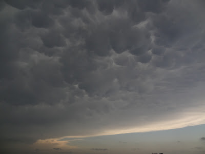
Very picturesque mammatus clouds above.

Me filming a rapidly developing multi-vortex tornado, south-west of El Reno, Oklahoma.

Same.

Large, wedge tornado near El Reno, Oklahoma - the tornado is the lighter cloud in the centre of frame.
Wedge tornado
Just finished dinner...will write this up when we get back to motel. Saw a multi-vortex wedge tornado today before having to escape to the east and south - probably the most intense chase of my life and a scary experience.
Subscribe to:
Posts (Atom)