Tuesday 24 June 2014

Looking back 20 years - the severe thunderstorms of June 24th 1994 in S England

As a first year student at Reading Uni in 1994, this day in that year was one which sticks in my mind - less for the maths exam I dashed through (passing, thankfully!), and more for the intense thunderstorms which developed/moved north during the evening.


It was a reasonably classic deep southerly flow, perhaps a Spanish Plume: 

During the previous evening, AcCas blossomed across the Reading sky as the EML drifted north - the 12Z Herstmonceux sounding from the 24th shows a pronounced EML. Modifying this with the Camborne 12Z 900-700hPa temperature profile (making a very broad assumption that the approaching upper trough from the west caused cooling via lifting above a capped boundary layer, across eastern areas, leading to a similar 900-700hPa profile to Camborne's) and using the max temps (29C) and approx dewpoints in the warm sector yields sizeable and deep CAPE. As the trough approached upper flow increased too, with enough shear for well organised multicell thunderstorms, and perhaps updraught rotation.

From my point of view, after finishing the exam I went back to my hall - after dinner, at around 6.30pm, a large, thick cirrus shield overspread the sky from the south. About an hour or so later a thunderstorm commenced, bringing frequent lightning, strong winds, and plenty of rain. It went on for a couple hours before moving away - it was a very impressive storm although I think the storms further east were even more intense.

Here is some BBC forecast footage:


And some YouTube footage from a chap in Great Baddow, Essex:

Thursday 5 June 2014

Home!

Hello! We're back home after this year's trip...it was an enjoyable one, even though it was a rather quieter year than some recents ones. Even so, we saw some great storms and had a lovely time.

To top it off we got bumped to business class for the flight home, which was nice!

Wednesday 4 June 2014

June 3rd - final day long shot - no!

Hello.

We thought we'd try a long shot at getting some afternoon convection in S Cent Nebraska - we knew all hell would break loose further north as storms fired along a warm front, but it was too far for us to go, knowing we had to head back to Dallas on Wednesday. Also, the type of storms expected - large, violent high-precipitation supercells with limited tornado potential, and little chance of seeing a photogenic tornado made it less appealing. So we gambled and drove from Salina, Kansas, to Red Cloud, Nebraska, which is a lovely little place. We had lunch and mooched around the local area for a couple of hours - very nice, but no storms.

At 5.30pm or so, it was clear nothing was going to happen soon, if at all, so we bailed, and drove to Oklahoma City. We stopped for McD's on the way down - our first of the whole trip!

We're staying overnight in N Oklahoma City, ready to drive to Dallas in the morning.

It's been a nice trip, if fairly quiet storm-wise. We've seen some cool storms and some nice structure at times, but no tornadoes this year.

Tuesday 3 June 2014

June 2nd - S Kansas bust

Hello.

It was a long shot to get convection today in the Plains, as an upper ridge built in, decreasing lapse rates and stifling any towers which could develop.

We decided to head to southern Kansas, just in case an old outflow boundary could cause enough low-level lift to allow storms to form. A few showers did develop in the end, and we did drive through some brief heavy rain - however, there just wasn't the persistent lift to really get things going, and the convection always looked fairly anaemic.

We decided to head to Salina - tomorrow, a large area of Nebraska and parts of N Kansas appear to be in line for a severe weather outbreak, with the risk of supercells and strong tornadoes. We have to be in Dallas on Wednesday for our flight home, so this will modulate how far north we are prepared to go tomorrow. We'll have to await the morning models and see how any overnight convection affects the set-up. If it appears it'll be well into Nebraska, we may just call it quits and start heading south - however, if there's a chance in S Nebraska/N Cent Kansas, which there may well be, we'll hang about.


Monday 2 June 2014

June 1st pics

Here are a few pics from yesterday.


June 1st - messy storms in Kansas

Hello.

We had a later start than planned as I turned off the alarm clock when it first woke me at around 0840 and thought we'd have 5 more minutes. When I next looked it was just after 1000! The plentiful driving and late nights have started to take their toll and so we needed the sleep. We packed our stuff, but thunderstorms were already developing/ongoing, and a strong gust front moved overhead around the time we wanted to check out. Cue torrential rain and strong winds! I reversed the car right up to a door, into a kind of porch area - it clearly wasn't meant to be used like that but we didn't want to get soaked!

We headed south into Kansas, and stopped for lunch in Oberlin. Several other chasers were there too. After a while a storm developed to the west, but soon fizzled. We decided to head south to intercept storms to the south and south-east of Oakley. We did this, but the storms morphed into something of a mess - this was expected today, but it's a shame it wasn't a bit later! Even so, we saw some great lightning and some interesting cloudscapes. We could have continued south to try to get to the south end of the line - which would have yielded better storms - but we decided to just hang around and take in the sights and sounds of the prairie, with the storms rumbling away.

Whilst taking some of this in, a car pulled up and a lady called Lori chatted to me for a while about storms and living in Kansas - it was lovely to meet her - the folks out here are very friendly.

We then decided to head east - another thunderstorm developed overhead and we watched that for a while - it gave us a great rainbow too.

We ended up in Hays, and ate in Applebee's - where else?! It was packed - some kind of dance event was going on.

No pics tonight as it's late now!

Sunday 1 June 2014

May 31st - Wyoming storms/funnel cloud

Hello.

We had a leisurely morning in Cheyenne - Helen did a little shopping for a few albums, etc, and we had lunch in Subway. By around 1.30-2pm a few storms were forming to the west and north-west, and we drove out of town to the north-east, and parked up to watch. We spent a pleasant couple of hours just watching a cell to our NW go through various stages of development, before eventually dying out. A new cell to our NW looked more promising, but a line of fairly weak storms to the south was pushing an outflow boundary northwards. We decided to head further north to be in a better position to intercept - I remarked to Helen that we should keep an eye on the base of the developing supercell as the gust front moved in - sure enough, in the distance to our west we saw a suspicious lowering quickly develop and take on a funnel shape. We pulled up as a report came in from chaser Daniel Shaw that a funnel had been spotted. It was around 30 miles to our west, but we just happened to be in a spot where we could see it across the open landscape (which, I should add, is stunning!).

After it disappeared we continued north and then west - at this time the supercell was being overtaken by the gust front from the south and south-west, and the base took on a more linear appearance. It still looked very cool and we got some good pictures. We then decided to head to Torrington to let the storm's core passed over - it did, with winds gusting to around 50mph and pea sized hail. Nothing too bad but still very nice nonetheless, and with plenty of thunder and lightning.

We then headed SE through Scottsbluff to I-80N (we saw a nice storm to our west, backlit by the setting sun, as we did so), and then to North Platte, where we're staying - we have a balcony! We ate dinner at Applebee's with Nathan Edwards.

Tomorrow brings a risk of severe storms over quite a large areas, especially Kansas. Scattered supercells with large hail and damaging winds, and perhaps a tornado, will likely grow upscale into one or more MCSs (Mesoscale Convective Systems) through the evening, and may pose a windspread damaging wind threat.


Saturday 31 May 2014

May 31st thoughts

Hello.

We're about to check out of our motel in Cheyenne. We'll probably hang around reasonably close to this area today...there is a slight risk of severe thunderstorms including supercells, and this area is one where storms can often form.

May 30th - Pike's Peak, then on to Wyoming

Hello.

Today we fulfilled an ambition: to drive up Pike's Peak in Colorado, to attain an altitude of over 14,000 feet above sea level in the comfort of our car! It was an experience which didn't disappoint! From waking up this morning and looking at the amazing view of the Garden of the Gods from our hotel room, to the slow drive up the mountain to the graupel and snow falling at the summit, the experience was fantastic. Yes, we had thick fog at the summit because of the cloud passing over, so we missed the spectacular views, but the cloud brought its own charm, and it always seems correct that one should pass into the clouds with altitude.

After a time, thunder boomed in the distance - an odd sound at this altitude as the thinner air gives the sound a different quality. We decided after about 40 minutes that it was time to descend - it was cold, and there's only so long we can look at fog! Also, although the effects of altitude were very minor for us, we could tell there was some subtle effects starting.

The slow drive down gave us time to stop and take pictures from time to time, and I was rather smug that the lady park ranger at the half-way down point said that our brakes were 'nice and cool' - which is ironic, as I usually like to get the brakes smoking!

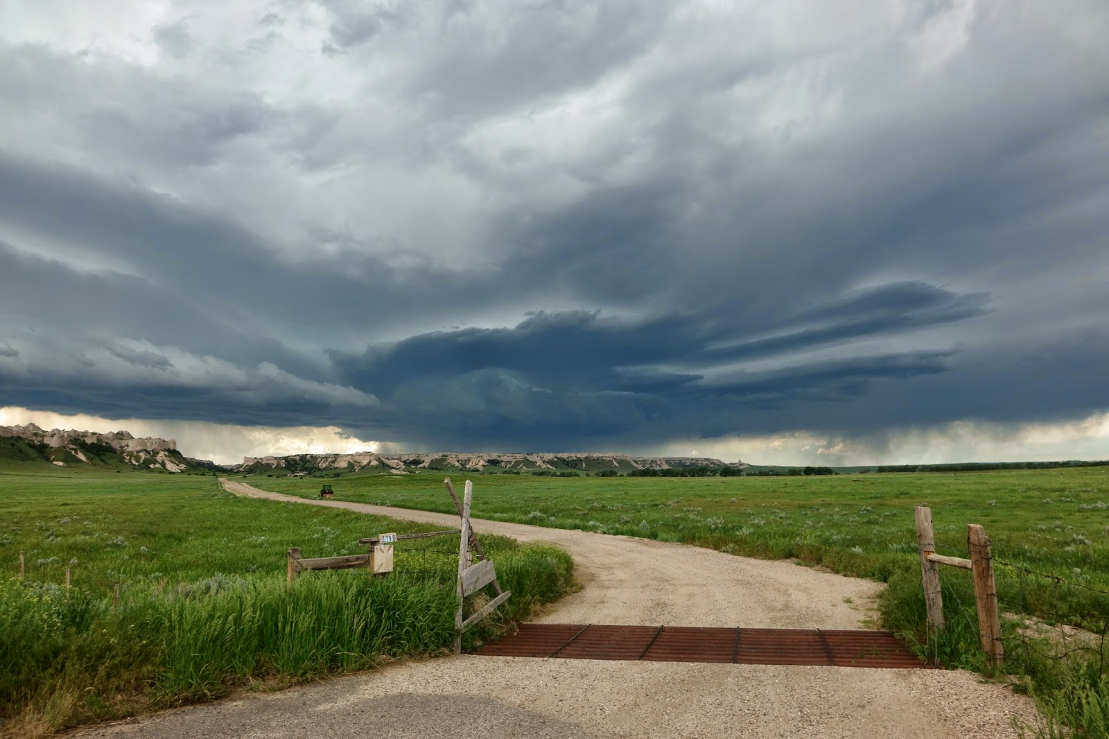
We then headed north through the very busy areas around Denver to Cheyenne, Wyoming, for the night. We encountered heavy rain and thunderstorms on the way here, with some great lightning.

We ate dinner at Applebee's with Nathan Edwards, and reflected on events a year ago - May 31st. 2013.

This was the day of the infamous El Reno, Oklahoma, tornado, which tragically took the lives of three experienced and extremely popular storm chasers: Tim and Paul Samaras, and Carl Young.

As you may recall we had a narrow escape from this tornado too - I've gone over this day many times since then. It's certainly had an effect on our chase methodology and I think it would be tragic if no-one learned from this day.

Looking back at my blog post from this evening - May 30th - last year, the last paragraph was:

Friday looks like being another volatile weather day for central Oklahoma, unfortunately. Once again the Oklahoma City area is in a risk area for severe thunderstorms including tornadoes, some of which could be strong, especially into the evening hours.

Of course, I penned these words knowing the atmosphere was primed for significant weather, but I could have hardly imagined, or even cared to imagine, what would follow. I think one thing to take from all of this is that a day is either a very normal thing for us: we go about our lives with normality, and we assume we'll do the same tomorrow, and so on; or it can be an historic day, or a tragic day.

Of course, one should never approach the new day with any sense of morbidity - but perhaps having a greater appreciation for each day, and the people around you and the experiences you have each day, is something which we should embrace more. I can't say I have always done this since last May 31 - but as we reach that tragic anniversary, perhaps it's time do it more.


Here are a few pics from today:

The view which greeted us this morning from our balcony.


Pike's Peak summit - pleasant weather! 1C and graupel/snow!


Us!


Graupel on my arm.


On the descent - thunder growling away too!


Snow.


This bottle was sealed at the summit, and then crushed by the higher pressure lower down.


Friday 30 May 2014

May 29th - Amarillo to Colorado Springs

Hello!

Today was another driving day - we intend to go up Pike's Peak tomorrow so we needed to be in position in Colorado Springs this evening. It's a lovely drive, with the vast prairie giving way to more rugged terrain as we moved into NE New Mexico - this is a vast, ancient landscape of volcanic origin, made very obvious by the extinct Capulin Volcano, which is a National Monument. We stopped to get some snaps.

We then continued into Colorado - by these stage, the skies to the west were painted an obsidian steely blue-grey, as thunderstorms across the Rockies were present. We noted several CG lightning bolts as a approached the storms - a stunning sight in a stunning landscape.

We're staying in the Garden of the Gods Club resort - our room has an amazing view of the Garden, as well as Pike's Peak beyond. I went for a swim this evening before we ordered room service! We thought we'd treat ourselves!

Capulin volcano


The view the other way


Thunderstorm in New Mexico, looking west from near Capulin


Me examining the hotel room!


The view from our balcony - the Garden of the Gods, with Pike's Peak in the background


Helen getting excited by our room service burgers!


Evening view from the balcony


Thursday 29 May 2014

The way to Amarillo - May 28th

Hello. Today was a driving day, from Austin to Amarillo - that means we stayed in Texas the whole time, and yet drove 501 miles! For those of you in the UK that's just shy of driving from Reading to Aviemore! The traffic was light, so the journey was nothing like trying to undertake the same length drive in the UK!

Tomorrow we're going to head to Colorado as we want to go up Pike's Peak, either later tomorrow or on Friday morning - this choice will be modulated by how the chance of storms is looking on Friday - if we believe some reasonable storms are likely in either the Denver area, or further north into Wyoming or perhaps western Nebraska, we may do Pike's Peak on Thursday afternoon, otherwise it may be an early trip up on Friday - the latter might be better as otherwise the views might be messed up by afternoon convection.

On this day last year we saw a big wedge tornado near Bennington, Kansas - this year we saw lots of sunshine!


Wednesday 28 May 2014

Driving to Amarillo likely today!

Just deciding what to do today...some chances for storms across the higher ground of the N Plains towards the mountains late week before perhaps a more widespread chance into next week in the northern and central Plains. To leave our options open and perhaps to tick off driving up Pike's Peak we'll probably head to Amarillo today so we can move up into CO tomorrow.

May 27th - central TX supercells

We started the day in San Antonio, and decided to drift across to Brownwood. It was more tricky today to pick a defined chase target area so we thought we'd let serendipity dictate any chase possibilities!

After lunching in Brownwood, and meeting up with Dan Holley and Chris Steele, we noticed showers developing close-by to our NW. As any activity would be moving SE we headed out of town and headed SSE towards Goldthwaite. We were in the heavy rain for a time, and the shower became a thunderstorm. With a SE storm motion, we needed to get across to the west side of the storm(s) to see any updraught. We did that after Goldthwaite by turning SW towards San Saba - we caught some nice supercellular features on the first storm, although a second storm became more dominant, and we also got some nice shots of this. The storm(s) we tornado warned, but although we saw some reasonable rotation at times early on, the HP nature of the storms meant we could not see anything tornadic - they seemed rather outflow dominant too.

We eventually wound our way around to Llano (having taken a diversion towards the Colorado Bend State Park) and thence to Burnet. We paused here to take stock, and decided to book a room in Austin for the night.

It's our first time in this part of Texas and I must say the scenery is amazing. Austin is also a cool city, especially by night with the big buildings lit up.

A very nice chase day, and we got to catch up with a few chasers, including Stu Robinson and Alistair Chapman.


Tuesday 27 May 2014

May 26th - supercells!

Hello!

We started the day in Odessa, Texas, and hung around the hotel until later in the afternoon as Helen wasn't feeling very well. Storms were firing to the north and north-west and I kept an eye on them on the radar, and also visually - they looked impressive as they erupted into the blue Texas sky.

Around 4pm or so we managed to depart, and targeted the southern cell. We raced up I20 to Stanton, and then headed across to Garden City. We noted strong rotation from time to time, although the cell was somewhat outflow dominant. Several wall clouds were observed, along with hail up to around 1 inch or a bit more. We dropped south from Garden City, as we didn't really want to run the gauntlet - we missed a couple of brief tornadoes, I think, by doing this, but we saw some stunning structure.

We then documented a second cell coming in from the west - this had a tornado warning on it, but from our vantage point it was too outflow dominant to be one which would spawn one, and it didn't, as far as we know. The storm did produce some hail larger than tennis balls though - we didn't want to get involved with its core!

We headed to Sterling City, and then gradually wound our way over to San Angelo, where we're staying the night. We saw some stunning lightning and I managed to get a few bolts on the new camera - I also did a little photography after dinner of the departing storms.


Monday 26 May 2014

May 26th thoughts

Hello. Rumbling this morning from outside turned out to be hundreds of bikes heading west...some kind of Memorial Day ride I imagine.


Today, several outflow boundaries exist across this area. We'll probably target a more major one which is fairly close by, heading initially to Big Spring and then seeing how it develops from there. Supercells are possible again, with a conditional tornado threat if any storm interacts with a boundary.

May 25th - another bust!

After getting woken up at around 5am by a thunderstorm in Odessa (so at least we had a storm today!) we headed to Fort Stockton, leaving the hotel around midday, and getting there in time for lunch. We then spent the next 5 1/2 hours in a futile wait for storms to form off a dry line to our west. It was a day to trust the HRRR model's depiction of a supercell moving across SE New Mexico, and those who gambled on it got a nice storm. We decided to hang tight to no avail. Headed back to Odessa for tonight, staying at the Best Western again. Saw a nice sunset, with the storm to the north. Ate dinner at Chilli's.

There was a great chaser convergence at Fort Stockton. Amongst others we saw Dave Lewison, Scott McPartland, Reed Timmer and the Dominator 4, Nathan Edwards, Cammie and Tim, Bill Hark, Lou Rou, Claire Hudson, Jolyane Limoges, Mark Robinson, to name a few.


Sunday 25 May 2014

Fort Stockton for lunch

Hello,

After several more thunderstorms rolled overhead late last night and this morning we got up and we've headed SSW to Fort Stockton, where we've paused for lunch. A tornado watch has been issued, as there are a couple of outflow boundaries in the area, a dry line to the west, and reasonable flow aloft atop low level SE or E winds, especially north of the boundaries. We have a brisk easterly in FSL just now - a thunderstorm has developed to the south, and was tornado warned for a time, but seems to be easing now - perhaps as it ingests some of the modified air behind the outflow boundary.

We have towering cumulus to our west, so we may sit here a little while to see whether they mature.

Early wake up call!

We thought we'd got away with an undisturbed night's sleep but we've been woken up by active thunderstorms here in Odessa! Plenty of thunder and lightning, with some very close bolts at times.

May 24th - Bust!

Today we had a bit of a lie in until 9am as we'd been kept awake for much of the night by some very active thunderstorms in Roswell. We knew that the best chance of severe weather was likely along an outflow boundary which was already quite far to our south, but we decided to drift southwards anyway, as a second round of storms was possible later, from an approaching upper disturbance. It was a bit tricky knowing quite where the second round would form. In the end, some storms formed close to where we'd started the day! Nothing formed around Pecos, where we ended up, during the afternoon, so we've headed to Odessa for the night.

Highlights today totalled three:

1) Helen mending our laptop cooler after the wire came out, by watching a YouTube video of someone with a slightly comedy voice demonstrating how to take it apart.
2) Being able to buy a pint of coffee for under 2 bucks.
3) Being able to legally drive at 80mph as this is the speed limit in west Texas.

Below - the sunshine in Pecos.

Saturday 24 May 2014

May 24th thoughts

Hello! We were kept up a lot of the night by spectacular thunderstorms which brought a record amount of rain for Roswell...see the tweet below from the NWS in Alberqueque:
4.39"  Airpark breaks all-time 24hr precip record back to 1946. Previous was 4.34" 7/13/1991

Today brings another risk of severe storms across parts of New Mexico and Texas, especially near an outflow boundary in the south of New Mexico. We'll head south from Roswell to see what happens.


May 23rd - New Mexico

Hello!

We started the day in Pueblo, Colorado - we had a very pleasant drive down I-25 into New Mexico, with the plan of reaching Hobbs by the end of the day, in order to target Saturday's risk. However, we also knew there was at least a small risk of catching some storms on the way down, and sure enough, several cells formed. We intercepted a couple of them close to Vaughn, New Mexico - the first exhibited some supercell structure, as did the second. They weren't especially long-lived, but they were severe warned for hail and wind, and we saw some great CG lightning, as well as some cool structure. The one annoyance for me was leaving my tripod unattended for a few mins and it was then blown over by some modest outflow winds. My video camera seems to be OK, luckily, bar some minor damage to the casing - it could have been a lot worse but it was certainly a reminder not to leave it!! We also saw Will Owen again, which was cool.

We ended the day in Roswell, New Mexico -we ate dinner at Applebee's, and there is now a line of storms to our west moving in - thus, it is likely to get quite noisy soon, as the storms move in.

Nice convection on our way south - this is looking west into the mountains.


First storm near Vaughn.


Train under first storm.


Second storm showing some supercell characteristics.


Friday 23 May 2014

May 23 thoughts

Hello. We're just considering our options for today at the moment. I was rudely awoken by a moth crawling across my face...I think it's some kind of payback for my views on last night's karaoke noise in the Applebee's.

Anyway, the next few days will see a risk of severe storms across parts of west Texas and eastern New Mexico. We'll head in that direction today, perhaps taking in any storms which might occur on the way.

May 22

Hello.

We had a good chase day today - intercepted a marginal supercell near Deer Trail/Byers in Colorado, after hanging around Limon for a time, waiting for things to get going. A Denver Cyclone and vorticity zone had set up, and these were the focus for showers/storms to get going, with others developing over the Rockies and drifting east. We got some nice structure for a time, and the cell(s) became severe warned. We hung back and just watched for 2 hours or so.

Beforehand we saw Paul Botten and Ian Miller - and then whilst watching the storm we were joined by Willoughby Owen, Cam Czuchnicki, and Tim Moxon - a great day!

Below is a selection of images from today.