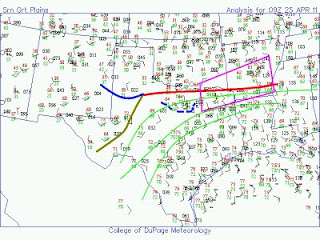
Several days of severe weather are likely across the USA, starting today. A deep upper trough will approach the central Plains states, with one short-wave trough moving through later today, before the main trough approaches tomorrow.
Strong southerly winds will develop ahead of these features, transporting Gulf moisture into the region, whilst a front will be draped in a general east-west fashion through the southern Plains and Mississippi river valley.
A dryline will mix eastwards this afternoon whilst a surface low develops and moves north-east. These will likely be foci for severe thunderstorms this afternoon, once morning convection across the area tends to shift away.
The image below is my analysis of the current situation - the purple box is where I think the best chance of tornadoes will be this afternoon/evening. NE Texas maybe a favoured location for mid-late afternoon supercells and tornadoes ahead of a dryline bulge. These storms will then likely propagate north-eastwards across Arkansas, but will likely grow upscale into one or more cluster(s) of storms, including supercells, as the upper trough moves in.
For a (virtual) chase target, I initially pick Clarksville, TX.

No comments:
Post a Comment